Verruyes geodata
Verruyes (Nouvelle-Aquitaine) is a populated place; located in France in Europe/Paris (GMT+2) time zone. With population of 928 people, there are 9405 cities with bigger population in this country. Compared to other cities in France, 60% of cities are located further ↑North; 80.7% of cities are located further →East and 63.1% of cities have lower elevation than Verruyes. Note1
Administrative division(s):
- Level 1: Nouvelle-Aquitaine
- Level 2: Département des Deux-Sèvres
- Level 3: Arrondissement de Parthenay
- Level 4: Verruyes


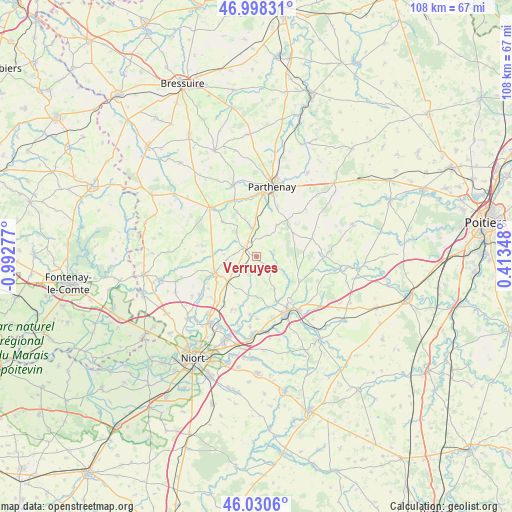
Verruyes GPS coordinates[2]
46° 30' 59.796" North, 0° 17' 22.74" West
| Map corner | latitude | longitude |
|---|---|---|
| Upper-left | 46.99831°, | -0.99277° |
| Center: | 46.51661°, | -0.28965° |
| Lower-right: | 46.0306°, | 0.41348° |
| Map W x H: | 107.6×107.6 km | = 66.9×66.9mi |
| max Lat: | 51.07786° ⇑60% North |
| Verruyes: | 46.51661° |
| min Lat: | ⇓40% South 41.3874° |
| min Long | Verruyes | max Long |
| -5.08615° | -0.28965° | 9.52242° |
| W 19.3%⇐ | ⇒80.7% E |
Elevation
Elevation of Verruyes is 185 m = 607 ft, and this is 8.7 m = 29 ft below average elevation for this country.
| Max E: |
2333 m = 7654 ft | 36.9% |
| Avg. | 193.7 m = 635 ft | |
| Verruyes | 185 m = 607 ft | |
Min E: |
-1 m = -3 ft | 63.1% |
See also: France elevation on elevation.city.
Geographical zone
Verruyes is located in North temperate zone (between Tropic of Cancer and the Arctic Circle). Distance of this North polar circle is 2229 km =1385 mi to North.| Distance of | km | miles | from Verruyes |
|---|---|---|---|
| North Pole | 4834.9 | 3004.3 | to North |
| Arctic Circle | 2229 | 1385 | to North |
| Tropic Cancer | 2566.2 | 1594.6 | to South |
| Equator | 5172.2 | 3213.9 | to South |


Nearby cities:
15 places around Verruyes: (largest is in red/bold)
• Allonne
10.2 km =6.3 mi,  315°
315°
• Augé
8.6 km =5.3 mi,  179°
179°
• Azay-le-Brûlé
13.2 km =8.2 mi,  165°
165°
• Azay-sur-Thouet
12.9 km =8 mi,  338°
338°
• Beaulieu-sous-Parthenay
7.9 km =4.9 mi,  32°
32°
• Champdeniers-Saint-Denis
9.2 km =5.7 mi,  246°
246°
• Cherveux
12.4 km =7.7 mi,  204°
204°
• Exireuil
11.9 km =7.4 mi,  141°
141°
• Germond-Rouvre
12.2 km =7.6 mi,  232°
232°
• Le Tallud
12.7 km =7.9 mi,  357°
357°
• Mazières-en-Gâtine
3.1 km =1.9 mi,  305°
305°
• Pompaire
11 km =6.8 mi,  22°
22°
• Saint-Georges-de-Noisné
3.6 km =2.2 mi, 136°
• Saint-Pardoux
6.2 km =3.9 mi,  348°
348°
• Saivres
10.2 km =6.3 mi,  156°
156°
Sources, notices
• [Note1] Compared only with cities in France existing in our database
• [Src1] Map data: © OpenStreetMap contributors (CC-BY-SA)
• [Src2] Other city data from geonames.org with taken over terms of usage.
• [Src3] Geographical zone / Annual Mean Temperature by Robert A. Rohde @ Wikipedia
