Beaucaire geodata
Beaucaire (Occitanie) is a populated place; located in France in Europe/Paris (GMT+2) time zone. With population of 14,766 people, there are 645 cities with bigger population in this country. Compared to other cities in France, 89% of cities are located further ↑North; 73.2% of cities are located further ←West and 93.1% of cities have higher elevation than Beaucaire. Note1
Administrative division(s):
- Level 1: Occitanie
- Level 2: Gard
- Level 3: Arrondissement de Nîmes
- Level 4: Beaucaire


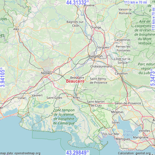
Beaucaire GPS coordinates[2]
43° 48' 29.016" North, 4° 38' 39.012" East
| Map corner | latitude | longitude |
|---|---|---|
| Upper-left | 44.31332°, | 3.94105° |
| Center: | 43.80806°, | 4.64417° |
| Lower-right: | 43.29849°, | 5.3473° |
| Map W x H: | 112.8×112.8 km | = 70.1×70.1mi |
| max Lat: | 51.07786° ⇑89% North |
| Beaucaire: | 43.80806° |
| min Lat: | ⇓11% South 41.3874° |
| min Long | Beaucaire | max Long |
| -5.08615° | 4.64417° | 9.52242° |
| W 73.2%⇐ | ⇒26.8% E |
Elevation
Elevation of Beaucaire is 22 m = 72 ft, and this is 171.7 m = 563 ft below average elevation for this country.
| Max E: |
2333 m = 7654 ft | 93.1% |
| Avg. | 193.7 m = 635 ft | |
| Beaucaire | 22 m = 72 ft | |
Min E: |
-1 m = -3 ft | 6.9% |
See also: France elevation on elevation.city.
Geographical zone
Beaucaire is located in North temperate zone (between Tropic of Cancer and the Arctic Circle). Distance of this Northern Tropic circle is 2265.1 km =1407.5 mi to South.| Distance of | km | miles | from Beaucaire |
|---|---|---|---|
| North Pole | 5136.1 | 3191.4 | to North |
| Arctic Circle | 2530.2 | 1572.2 | to North |
| Tropic Cancer | 2265.1 | 1407.5 | to South |
| Equator | 4871 | 3026.7 | to South |


Nearby cities:
15 places around Beaucaire: (largest is in red/bold)
• Aramon
9.8 km =6.1 mi,  17°
17°
• Bellegarde
11.9 km =7.4 mi,  239°
239°
• Boulbon
7.2 km =4.5 mi,  33°
33°
• Comps
5.9 km =3.7 mi,  328°
328°
• Fontvieille
10.3 km =6.4 mi,  149°
149°
• Graveson
11.4 km =7.1 mi,  65°
65°
• Jonquières-Saint-Vincent
6.9 km =4.3 mi,  288°
288°
• Maillane
11.4 km =7.1 mi,  75°
75°
• Meynes
10.5 km =6.5 mi,  319°
319°
• Montfrin
8.4 km =5.2 mi, 334°
• Redessan
12 km =7.5 mi,  282°
282°
• Saint-Étienne-du-Grès
7.2 km =4.5 mi,  115°
115°
• Tarascon
1.3 km =0.8 mi,  100°
100°
• Théziers
10.4 km =6.5 mi,  350°
350°
• Vallabrègues
5.2 km =3.2 mi,  344°
344°
Sources, notices
• [Note1] Compared only with cities in France existing in our database
• [Src1] Map data: © OpenStreetMap contributors (CC-BY-SA)
• [Src2] Other city data from geonames.org with taken over terms of usage.
• [Src3] Geographical zone / Annual Mean Temperature by Robert A. Rohde @ Wikipedia
