Redessan geodata
Redessan (Occitanie) is a populated place; located in France in Europe/Paris (GMT+2) time zone. With population of 3,113 people, there are 3135 cities with bigger population in this country. Compared to other cities in France, 88.8% of cities are located further ↑North; 72.1% of cities are located further ←West and 76.6% of cities have higher elevation than Redessan. Note1
Administrative division(s):
- Level 1: Occitanie
- Level 2: Gard
- Level 3: Arrondissement de Nîmes
- Level 4: Redessan


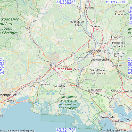
Redessan GPS coordinates[2]
43° 49' 52.212" North, 4° 29' 51.756" East
| Map corner | latitude | longitude |
|---|---|---|
| Upper-left | 44.33624°, | 3.79458° |
| Center: | 43.83117°, | 4.49771° |
| Lower-right: | 43.32179°, | 5.20083° |
| Map W x H: | 112.8×112.8 km | = 70.1×70.1mi |
| max Lat: | 51.07786° ⇑88.8% North |
| Redessan: | 43.83117° |
| min Lat: | ⇓11.2% South 41.3874° |
| min Long | Redessan | max Long |
| -5.08615° | 4.49771° | 9.52242° |
| W 72.1%⇐ | ⇒27.9% E |
Elevation
Elevation of Redessan is 63 m = 207 ft, and this is 130.7 m = 429 ft below average elevation for this country.
| Max E: |
2333 m = 7654 ft | 76.6% |
| Avg. | 193.7 m = 635 ft | |
| Redessan | 63 m = 207 ft | |
Min E: |
-1 m = -3 ft | 23.4% |
See also: France elevation on elevation.city.
Geographical zone
Redessan is located in North temperate zone (between Tropic of Cancer and the Arctic Circle). Distance of this Northern Tropic circle is 2267.7 km =1409.1 mi to South.| Distance of | km | miles | from Redessan |
|---|---|---|---|
| North Pole | 5133.5 | 3189.8 | to North |
| Arctic Circle | 2527.6 | 1570.6 | to North |
| Tropic Cancer | 2267.7 | 1409.1 | to South |
| Equator | 4873.6 | 3028.3 | to South |


Nearby cities:
15 places around Redessan: (largest is in red/bold)
• Bellegarde
8.8 km =5.5 mi,  170°
170°
• Bezouce
5.7 km =3.5 mi,  354°
354°
• Bouillargues
6.7 km =4.2 mi,  235°
235°
• Cabrières
8.4 km =5.2 mi, 345°
• Comps
9 km =5.6 mi,  74°
74°
• Garons
9 km =5.6 mi,  218°
218°
• Jonquières-Saint-Vincent
5.3 km =3.3 mi,  93°
93°
• Lédenon
9.3 km =5.8 mi,  8°
8°
• Manduel
2.5 km =1.6 mi, 235°
• Marguerittes
5.3 km =3.3 mi,  306°
306°
• Meynes
7.3 km =4.5 mi,  42°
42°
• Montfrin
9.6 km =6 mi,  58°
58°
• Rodilhan
5.4 km =3.4 mi,  265°
265°
• Saint-Gervasy
5.7 km =3.5 mi,  333°
333°
• Sernhac
9.8 km =6.1 mi,  25°
25°
Sources, notices
• [Note1] Compared only with cities in France existing in our database
• [Src1] Map data: © OpenStreetMap contributors (CC-BY-SA)
• [Src2] Other city data from geonames.org with taken over terms of usage.
• [Src3] Geographical zone / Annual Mean Temperature by Robert A. Rohde @ Wikipedia
