Saint-Étienne-du-Grès geodata
Saint-Étienne-du-Grès (Provence-Alpes-Côte d'Azur) is a populated place; located in France in Europe/Paris (GMT+2) time zone. With population of 2,239 people, there are 4296 cities with bigger population in this country. Compared to other cities in France, 89.3% of cities are located further ↑North; 74.1% of cities are located further ←West and 89.5% of cities have higher elevation than Saint-Étienne-du-Grès. Note1
Administrative division(s):
- Level 1: Provence-Alpes-Côte d'Azur
- Level 2: Département des Bouches-du-Rhône
- Level 3: Arles
- Level 4: Saint-Étienne-du-Grès


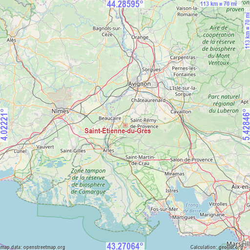
Saint-Étienne-du-Grès GPS coordinates[2]
43° 46' 49.62" North, 4° 43' 31.224" East
| Map corner | latitude | longitude |
|---|---|---|
| Upper-left | 44.28595°, | 4.02221° |
| Center: | 43.78045°, | 4.72534° |
| Lower-right: | 43.27064°, | 5.42846° |
| Map W x H: | 112.9×112.9 km | = 70.2×70.2mi |
| max Lat: | 51.07786° ⇑89.3% North |
| Saint-Étienne-du-Grès: | 43.78045° |
| min Lat: | ⇓10.7% South 41.3874° |
| min Long | Saint-Étienne- | max Long |
| -5.08615° | 4.72534° | 9.52242° |
| W 74.1%⇐ | ⇒25.9% E |
Elevation
Elevation of Saint-Étienne-du-Grès is 31 m = 102 ft, and this is 162.7 m = 534 ft below average elevation for this country.
| Max E: |
2333 m = 7654 ft | 89.5% |
| Avg. | 193.7 m = 635 ft | |
| Saint-Étienne-du-Grès | 31 m = 102 ft | |
Min E: |
-1 m = -3 ft | 10.5% |
See also: France elevation on elevation.city.
Geographical zone
Saint-Étienne-du-Grès is located in North temperate zone (between Tropic of Cancer and the Arctic Circle). Distance of this Northern Tropic circle is 2262 km =1405.5 mi to South.| Distance of | km | miles | from Saint-Étienne-du-Grès |
|---|---|---|---|
| North Pole | 5139.1 | 3193.3 | to North |
| Arctic Circle | 2533.2 | 1574.1 | to North |
| Tropic Cancer | 2262 | 1405.5 | to South |
| Equator | 4867.9 | 3024.8 | to South |


Nearby cities:
15 places around Saint-Étienne-du-Grès: (largest is in red/bold)
• Aramon
12.9 km =8 mi,  343°
343°
• Barbentane
13.3 km =8.3 mi,  7°
7°
• Beaucaire
7.2 km =4.5 mi,  295°
295°
• Boulbon
9.4 km =5.8 mi, 344°
• Comps
12.5 km =7.8 mi,  310°
310°
• Eyragues
11.6 km =7.2 mi,  54°
54°
• Fontvieille
6 km =3.7 mi,  192°
192°
• Fourques
13.3 km =8.3 mi,  224°
224°
• Graveson
8.7 km =5.4 mi,  26°
26°
• Maillane
7.4 km =4.6 mi,  37°
37°
• Maussane-les-Alpilles
9.1 km =5.7 mi,  135°
135°
• Paradou
8.6 km =5.3 mi,  145°
145°
• Saint-Rémy-de-Provence
8.6 km =5.3 mi,  84°
84°
• Tarascon
5.9 km =3.7 mi, 298°
• Vallabrègues
11.3 km =7 mi,  315°
315°
Sources, notices
• [Note1] Compared only with cities in France existing in our database
• [Src1] Map data: © OpenStreetMap contributors (CC-BY-SA)
• [Src2] Other city data from geonames.org with taken over terms of usage.
• [Src3] Geographical zone / Annual Mean Temperature by Robert A. Rohde @ Wikipedia
