Entremont-le-Vieux geodata
Entremont-le-Vieux (Auvergne-Rhône-Alpes) is a populated place; located in France in Europe/Paris (GMT+2) time zone. With population of 561 people, there are 13985 cities with bigger population in this country. Compared to other cities in France, 74.8% of cities are located further ↑North; 85.8% of cities are located further ←West and 99% of cities have lower elevation than Entremont-le-Vieux. Note1
Administrative division(s):
- Level 1: Auvergne-Rhône-Alpes
- Level 2: Savoie
- Level 3: Arrondissement de Chambéry
- Level 4: Entremont-le-Vieux


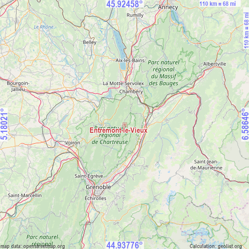
Entremont-le-Vieux GPS coordinates[2]
45° 25' 59.988" North, 5° 52' 59.988" East
| Map corner | latitude | longitude |
|---|---|---|
| Upper-left | 45.92458°, | 5.18021° |
| Center: | 45.43333°, | 5.88333° |
| Lower-right: | 44.93776°, | 6.58646° |
| Map W x H: | 109.7×109.7 km | = 68.2×68.2mi |
| max Lat: | 51.07786° ⇑74.8% North |
| Entremont-le-Vieux: | 45.43333° |
| min Lat: | ⇓25.2% South 41.3874° |
| min Long | Entremont-le-Vi | max Long |
| -5.08615° | 5.88333° | 9.52242° |
| W 85.8%⇐ | ⇒14.2% E |
Elevation
Elevation of Entremont-le-Vieux is 975 m = 3199 ft, and this is 781.3 m = 2563 ft above average elevation for this country.
| Max E: |
2333 m = 7654 ft | 1% |
| Entremont-le-Vieux | 975 m 3199 ft | |
| Avg. | 193.7 m = 635 ft | |
Min E: |
-1 m = -3 ft | 99% |
See also: France elevation on elevation.city.
Geographical zone
Entremont-le-Vieux is located in North temperate zone (between Tropic of Cancer and the Arctic Circle). Distance of this North polar circle is 2349.5 km =1459.9 mi to North.| Distance of | km | miles | from Entremont-le-Vieux |
|---|---|---|---|
| North Pole | 4955.3 | 3079.1 | to North |
| Arctic Circle | 2349.5 | 1459.9 | to North |
| Tropic Cancer | 2445.8 | 1519.7 | to South |
| Equator | 5051.7 | 3139 | to South |


Nearby cities:
15 places around Entremont-le-Vieux: (largest is in red/bold)
• Apremont
9.1 km =5.7 mi,  35°
35°
• Barraux
7.5 km =4.7 mi,  91°
91°
• Chapareillan
9.2 km =5.7 mi,  67°
67°
• Entre-Deux-Guiers
10.2 km =6.3 mi,  268°
268°
• La Buissière
8.6 km =5.3 mi,  115°
115°
• Le Cheylas
11 km =6.8 mi,  129°
129°
• Le Touvet
9.9 km =6.2 mi,  146°
146°
• Les Échelles
10.5 km =6.5 mi, 274°
• Pontcharra
10.5 km =6.5 mi, 88°
• Saint-Bernard
11.7 km =7.3 mi,  172°
172°
• Saint-Cassin
11.4 km =7.1 mi,  4°
4°
• Saint-Christophe-sur-Guiers
8.6 km =5.3 mi, 274°
• Saint-Pierre-de-Chartreuse
11.4 km =7.1 mi,  207°
207°
• Saint-Thibaud-de-Couz
8.1 km =5 mi,  338°
338°
• Saint-Vincent-de-Mercuze
8.8 km =5.5 mi,  140°
140°
Sources, notices
• [Note1] Compared only with cities in France existing in our database
• [Src1] Map data: © OpenStreetMap contributors (CC-BY-SA)
• [Src2] Other city data from geonames.org with taken over terms of usage.
• [Src3] Geographical zone / Annual Mean Temperature by Robert A. Rohde @ Wikipedia
