Gouvix geodata
Gouvix (Normandy) is a populated place; located in France in Europe/Paris (GMT+2) time zone. With population of 852 people, there are 10061 cities with bigger population in this country. Compared to other cities in France, 80.5% of cities are located further ↓South; 80.9% of cities are located further →East and 65.6% of cities have higher elevation than Gouvix. Note1
Administrative division(s):
- Level 1: Normandy
- Level 2: Calvados
- Level 3: Arrondissement de Caen
- Level 4: Gouvix


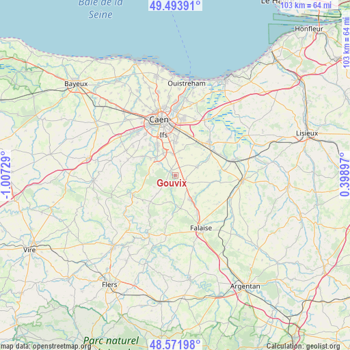
Gouvix GPS coordinates[2]
49° 2' 6.288" North, 0° 18' 14.976" West
| Map corner | latitude | longitude |
|---|---|---|
| Upper-left | 49.49391°, | -1.00729° |
| Center: | 49.03508°, | -0.30416° |
| Lower-right: | 48.57198°, | 0.39897° |
| Map W x H: | 102.5×102.5 km | = 63.7×63.7mi |
| max Lat: | 51.07786° ⇑19.5% North |
| Gouvix: | 49.03508° |
| min Lat: | ⇓80.5% South 41.3874° |
| min Long | Gouvix | max Long |
| -5.08615° | -0.30416° | 9.52242° |
| W 19.1%⇐ | ⇒80.9% E |
Elevation
Elevation of Gouvix is 88 m = 289 ft, and this is 105.7 m = 347 ft below average elevation for this country.
| Max E: |
2333 m = 7654 ft | 65.6% |
| Avg. | 193.7 m = 635 ft | |
| Gouvix | 88 m = 289 ft | |
Min E: |
-1 m = -3 ft | 34.4% |
See also: France elevation on elevation.city.
Geographical zone
Gouvix is located in North temperate zone (between Tropic of Cancer and the Arctic Circle). Distance of this North polar circle is 1949 km =1211.1 mi to North.| Distance of | km | miles | from Gouvix |
|---|---|---|---|
| North Pole | 4554.9 | 2830.3 | to North |
| Arctic Circle | 1949 | 1211.1 | to North |
| Tropic Cancer | 2846.3 | 1768.6 | to South |
| Equator | 5452.2 | 3387.8 | to South |


Nearby cities:
15 places around Gouvix: (largest is in red/bold)
• Barbery
4.6 km =2.9 mi,  231°
231°
• Boulon
6.6 km =4.1 mi,  281°
281°
• Bretteville-sur-Laize
1.9 km =1.2 mi,  303°
303°
• Cesny-Bois-Halbout
8.4 km =5.2 mi, 232°
• Clinchamps-sur-Orne
8.6 km =5.3 mi, 304°
• Fontenay-le-Marmion
7.4 km =4.6 mi,  331°
331°
• Fresney-le-Puceux
5.7 km =3.5 mi, 302°
• Garcelles-Secqueville
7.2 km =4.5 mi,  8°
8°
• Grainville-Langannerie
3.4 km =2.1 mi,  140°
140°
• Ouilly-le-Tesson
8.1 km =5 mi,  131°
131°
• Potigny
8.6 km =5.3 mi,  148°
148°
• Rocquancourt
6.6 km =4.1 mi,  349°
349°
• Saint-Germain-le-Vasson
3.7 km =2.3 mi,  176°
176°
• Saint-Sylvain
6.7 km =4.2 mi,  69°
69°
• Soumont-Saint-Quentin
8.1 km =5 mi, 140°
Sources, notices
• [Note1] Compared only with cities in France existing in our database
• [Src1] Map data: © OpenStreetMap contributors (CC-BY-SA)
• [Src2] Other city data from geonames.org with taken over terms of usage.
• [Src3] Geographical zone / Annual Mean Temperature by Robert A. Rohde @ Wikipedia
