Soumont-Saint-Quentin geodata
Soumont-Saint-Quentin (Normandy) is a populated place; located in France in Europe/Paris (GMT+2) time zone. With population of 505 people, there are 15148 cities with bigger population in this country. Compared to other cities in France, 79.2% of cities are located further ↓South; 80.1% of cities are located further →East and 52.5% of cities have lower elevation than Soumont-Saint-Quentin. Note1
Administrative division(s):
- Level 1: Normandy
- Level 2: Calvados
- Level 3: Arrondissement de Caen
- Level 4: Soumont-Saint-Quentin
Current local time in Soumont-Saint-Quentin:
09:59 PM, SaturdayDifference from your time zone: hours


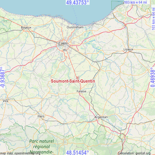
Soumont-Saint-Quentin GPS coordinates[2]
48° 58' 41.412" North, 0° 14' 1.5" West
| Map corner | latitude | longitude |
|---|---|---|
| Upper-left | 49.43753°, | -0.93687° |
| Center: | 48.97817°, | -0.23375° |
| Lower-right: | 48.51454°, | 0.46938° |
| Map W x H: | 102.6×102.6 km | = 63.8×63.8mi |
| max Lat: | 51.07786° ⇑20.8% North |
| Soumont-Saint-Quentin: | 48.97817° |
| min Lat: | ⇓79.2% South 41.3874° |
| min Long | Soumont-Saint-Q | max Long |
| -5.08615° | -0.23375° | 9.52242° |
| W 19.9%⇐ | ⇒80.1% E |
Elevation
Elevation of Soumont-Saint-Quentin is 141 m = 463 ft, and this is 52.7 m = 173 ft below average elevation for this country.
| Max E: |
2333 m = 7654 ft | 47.5% |
| Avg. | 193.7 m = 635 ft | |
| Soumont-Saint-Quentin | 141 m = 463 ft | |
Min E: |
-1 m = -3 ft | 52.5% |
See also: France elevation on elevation.city.
Geographical zone
Soumont-Saint-Quentin is located in North temperate zone (between Tropic of Cancer and the Arctic Circle). Distance of this North polar circle is 1955.3 km =1215 mi to North.| Distance of | km | miles | from Soumont-Saint-Quentin |
|---|---|---|---|
| North Pole | 4561.2 | 2834.2 | to North |
| Arctic Circle | 1955.3 | 1215 | to North |
| Tropic Cancer | 2839.9 | 1764.6 | to South |
| Equator | 5445.9 | 3383.9 | to South |


Nearby cities:
15 places around Soumont-Saint-Quentin: (largest is in red/bold)
• Barbery
9.4 km =5.8 mi,  291°
291°
• Bretteville-sur-Laize
10 km =6.2 mi,  317°
317°
• Cesny-Bois-Halbout
11.8 km =7.3 mi,  275°
275°
• Falaise
10 km =6.2 mi,  163°
163°
• Gouvix
8.1 km =5 mi, 320°
• Grainville-Langannerie
4.7 km =2.9 mi, 321°
• La Hoguette
12.5 km =7.8 mi, 155°
• Magny-la-Campagne
12.3 km =7.6 mi,  50°
50°
• Ouilly-le-Tesson
1.3 km =0.8 mi,  44°
44°
• Potigny
1.1 km =0.7 mi,  210°
210°
• Saint-Germain-le-Vasson
5.6 km =3.5 mi,  298°
298°
• Saint-Sylvain
8.8 km =5.5 mi,  7°
7°
• Ussy
4.9 km =3 mi,  227°
227°
• Vendeuvre
11.7 km =7.3 mi,  83°
83°
• Villers-Canivet
4.5 km =2.8 mi,  200°
200°
Sources, notices
• [Note1] Compared only with cities in France existing in our database
• [Src1] Map data: © OpenStreetMap contributors (CC-BY-SA)
• [Src2] Other city data from geonames.org with taken over terms of usage.
• [Src3] Geographical zone / Annual Mean Temperature by Robert A. Rohde @ Wikipedia
