Balsac geodata
Balsac (Occitanie) is a populated place; located in France in Europe/Paris (GMT+2) time zone. With population of 525 people, there are 14719 cities with bigger population in this country. Compared to other cities in France, 84.2% of cities are located further ↑North; 50.3% of cities are located further →East and 94.9% of cities have lower elevation than Balsac. Note1
Administrative division(s):
- Level 1: Occitanie
- Level 2: Département de l'Aveyron
- Level 3: Arrondissement de Rodez
- Level 4: Druelle Balsac


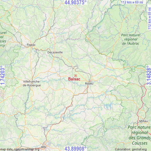
Balsac GPS coordinates[2]
44° 24' 12.852" North, 2° 26' 42.54" East
| Map corner | latitude | longitude |
|---|---|---|
| Upper-left | 44.90375°, | 1.74203° |
| Center: | 44.40357°, | 2.44515° |
| Lower-right: | 43.89908°, | 3.14828° |
| Map W x H: | 111.7×111.7 km | = 69.4×69.4mi |
| max Lat: | 51.07786° ⇑84.2% North |
| Balsac: | 44.40357° |
| min Lat: | ⇓15.8% South 41.3874° |
| min Long | Balsac | max Long |
| -5.08615° | 2.44515° | 9.52242° |
| W 49.7%⇐ | ⇒50.3% E |
Elevation
Elevation of Balsac is 581 m = 1906 ft, and this is 387.3 m = 1271 ft above average elevation for this country.
| Max E: |
2333 m = 7654 ft | 5.1% |
| Balsac | 581 m 1906 ft | |
| Avg. | 193.7 m = 635 ft | |
Min E: |
-1 m = -3 ft | 94.9% |
See also: France elevation on elevation.city.
Geographical zone
Balsac is located in North temperate zone (between Tropic of Cancer and the Arctic Circle). Distance of this Northern Tropic circle is 2331.3 km =1448.6 mi to South.| Distance of | km | miles | from Balsac |
|---|---|---|---|
| North Pole | 5069.8 | 3150.2 | to North |
| Arctic Circle | 2464 | 1531.1 | to North |
| Tropic Cancer | 2331.3 | 1448.6 | to South |
| Equator | 4937.2 | 3067.8 | to South |


Nearby cities:
15 places around Balsac: (largest is in red/bold)
• Auzits
14.7 km =9.1 mi,  320°
320°
• Baraqueville
14.2 km =8.8 mi,  184°
184°
• Colombiès
10.8 km =6.7 mi,  232°
232°
• Druelle
6.8 km =4.2 mi,  135°
135°
• Le Monastère
12.7 km =7.9 mi,  122°
122°
• Luc-la-Primaube
12.2 km =7.6 mi, 144°
• Marcillac-Vallon
8.1 km =5 mi,  11°
11°
• Moyrazès
6.9 km =4.3 mi, 183°
• Olemps
10.6 km =6.6 mi,  126°
126°
• Rignac
12.3 km =7.6 mi,  272°
272°
• Rodez
11.7 km =7.3 mi, 119°
• Saint-Christophe-Vallon
7.9 km =4.9 mi,  340°
340°
• Salles-la-Source
6.4 km =4 mi,  56°
56°
• Sébazac-Concourès
12.6 km =7.8 mi,  89°
89°
• Valady
6 km =3.7 mi,  346°
346°
Sources, notices
• [Note1] Compared only with cities in France existing in our database
• [Src1] Map data: © OpenStreetMap contributors (CC-BY-SA)
• [Src2] Other city data from geonames.org with taken over terms of usage.
• [Src3] Geographical zone / Annual Mean Temperature by Robert A. Rohde @ Wikipedia
