Druelle geodata
Druelle (Occitanie) is a populated place; located in France in Europe/Paris (GMT+2) time zone. With population of 1,775 people, there are 5344 cities with bigger population in this country. Compared to other cities in France, 84.5% of cities are located further ↑North; 50.7% of cities are located further ←West and 95.2% of cities have lower elevation than Druelle. Note1
Administrative division(s):
- Level 1: Occitanie
- Level 2: Département de l'Aveyron
- Level 3: Arrondissement de Rodez
- Level 4: Druelle Balsac


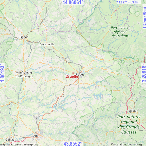
Druelle GPS coordinates[2]
44° 21' 36.216" North, 2° 30' 18.18" East
| Map corner | latitude | longitude |
|---|---|---|
| Upper-left | 44.86061°, | 1.80193° |
| Center: | 44.36006°, | 2.50505° |
| Lower-right: | 43.8552°, | 3.20818° |
| Map W x H: | 111.8×111.8 km | = 69.5×69.5mi |
| max Lat: | 51.07786° ⇑84.5% North |
| Druelle: | 44.36006° |
| min Lat: | ⇓15.5% South 41.3874° |
| min Long | Druelle | max Long |
| -5.08615° | 2.50505° | 9.52242° |
| W 50.7%⇐ | ⇒49.3% E |
Elevation
Elevation of Druelle is 597 m = 1959 ft, and this is 403.3 m = 1323 ft above average elevation for this country.
| Max E: |
2333 m = 7654 ft | 4.8% |
| Druelle | 597 m 1959 ft | |
| Avg. | 193.7 m = 635 ft | |
Min E: |
-1 m = -3 ft | 95.2% |
See also: France elevation on elevation.city.
Geographical zone
Druelle is located in North temperate zone (between Tropic of Cancer and the Arctic Circle). Distance of this Northern Tropic circle is 2326.5 km =1445.6 mi to South.| Distance of | km | miles | from Druelle |
|---|---|---|---|
| North Pole | 5074.7 | 3153.3 | to North |
| Arctic Circle | 2468.8 | 1534 | to North |
| Tropic Cancer | 2326.5 | 1445.6 | to South |
| Equator | 4932.4 | 3064.9 | to South |


Nearby cities:
15 places around Druelle: (largest is in red/bold)
• Balsac
6.8 km =4.2 mi,  315°
315°
• Baraqueville
11 km =6.8 mi,  212°
212°
• Calmont
12.4 km =7.7 mi,  177°
177°
• Flavin
11.2 km =7 mi,  134°
134°
• La Loubière
13 km =8.1 mi,  84°
84°
• Le Monastère
6.3 km =3.9 mi,  109°
109°
• Luc-la-Primaube
5.6 km =3.5 mi,  154°
154°
• Manhac
12.1 km =7.5 mi,  193°
193°
• Moyrazès
5.6 km =3.5 mi,  249°
249°
• Olemps
4 km =2.5 mi, 112°
• Rodez
5.5 km =3.4 mi,  98°
98°
• Sainte-Radegonde
10 km =6.2 mi, 104°
• Salles-la-Source
8.4 km =5.2 mi,  4°
4°
• Sébazac-Concourès
9.3 km =5.8 mi,  57°
57°
• Valady
12.4 km =7.7 mi,  330°
330°
Sources, notices
• [Note1] Compared only with cities in France existing in our database
• [Src1] Map data: © OpenStreetMap contributors (CC-BY-SA)
• [Src2] Other city data from geonames.org with taken over terms of usage.
• [Src3] Geographical zone / Annual Mean Temperature by Robert A. Rohde @ Wikipedia
