Ballots geodata
Ballots (Pays de la Loire) is a populated place; located in France in Europe/Paris (GMT+2) time zone. With population of 1,089 people, there are 8201 cities with bigger population in this country. Compared to other cities in France, 57.5% of cities are located further ↓South; 88.6% of cities are located further →East and 69.7% of cities have higher elevation than Ballots. Note1
Administrative division(s):
- Level 1: Pays de la Loire
- Level 2: Mayenne
- Level 3: Arrondissement de Château-Gontier
- Level 4: Ballots


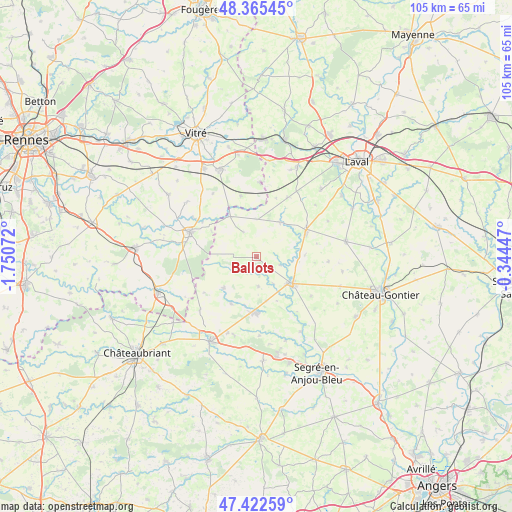
Ballots GPS coordinates[2]
47° 53' 46.212" North, 1° 2' 51.324" West
| Map corner | latitude | longitude |
|---|---|---|
| Upper-left | 48.36545°, | -1.75072° |
| Center: | 47.89617°, | -1.04759° |
| Lower-right: | 47.42259°, | -0.34447° |
| Map W x H: | 104.8×104.8 km | = 65.1×65.1mi |
| max Lat: | 51.07786° ⇑42.5% North |
| Ballots: | 47.89617° |
| min Lat: | ⇓57.5% South 41.3874° |
| min Long | Ballots | max Long |
| -5.08615° | -1.04759° | 9.52242° |
| W 11.4%⇐ | ⇒88.6% E |
Elevation
Elevation of Ballots is 79 m = 259 ft, and this is 114.7 m = 376 ft below average elevation for this country.
| Max E: |
2333 m = 7654 ft | 69.7% |
| Avg. | 193.7 m = 635 ft | |
| Ballots | 79 m = 259 ft | |
Min E: |
-1 m = -3 ft | 30.3% |
See also: France elevation on elevation.city.
Geographical zone
Ballots is located in North temperate zone (between Tropic of Cancer and the Arctic Circle). Distance of this North polar circle is 2075.6 km =1289.7 mi to North.| Distance of | km | miles | from Ballots |
|---|---|---|---|
| North Pole | 4681.5 | 2908.9 | to North |
| Arctic Circle | 2075.6 | 1289.7 | to North |
| Tropic Cancer | 2719.6 | 1689.9 | to South |
| Equator | 5325.6 | 3309.2 | to South |


Nearby cities:
15 places around Ballots: (largest is in red/bold)
• Athée
7.3 km =4.5 mi,  98°
98°
• Availles-sur-Seiche
13.3 km =8.3 mi,  303°
303°
• Bouchamps-lès-Craon
9.9 km =6.2 mi,  155°
155°
• Brielles
12.9 km =8 mi,  345°
345°
• Congrier
10.9 km =6.8 mi,  208°
208°
• Cossé-le-Vivien
11.5 km =7.1 mi,  61°
61°
• Craon
9.2 km =5.7 mi,  126°
126°
• Cuillé
9.9 km =6.2 mi,  327°
327°
• Gennes-sur-Seiche
11.7 km =7.3 mi, 330°
• La Selle-Craonnaise
5.9 km =3.7 mi,  176°
176°
• Livré-la-Touche
6.2 km =3.9 mi, 103°
• Méral
8.7 km =5.4 mi,  34°
34°
• Renazé
11.4 km =7.1 mi, 182°
• Saint-Aignan-sur-Roë
9.1 km =5.7 mi,  226°
226°
• Saint-Saturnin-du-Limet
9.5 km =5.9 mi,  188°
188°
Sources, notices
• [Note1] Compared only with cities in France existing in our database
• [Src1] Map data: © OpenStreetMap contributors (CC-BY-SA)
• [Src2] Other city data from geonames.org with taken over terms of usage.
• [Src3] Geographical zone / Annual Mean Temperature by Robert A. Rohde @ Wikipedia
