Baix geodata
Baix (Auvergne-Rhône-Alpes) is a populated place; located in France in Europe/Paris (GMT+2) time zone. With population of 864 people, there are 9950 cities with bigger population in this country. Compared to other cities in France, 82% of cities are located further ↑North; 74.6% of cities are located further ←West and 65.6% of cities have higher elevation than Baix. Note1
Administrative division(s):
- Level 1: Auvergne-Rhône-Alpes
- Level 2: Département de l'Ardèche
- Level 3: Arrondissement de Privas
- Level 4: Baix


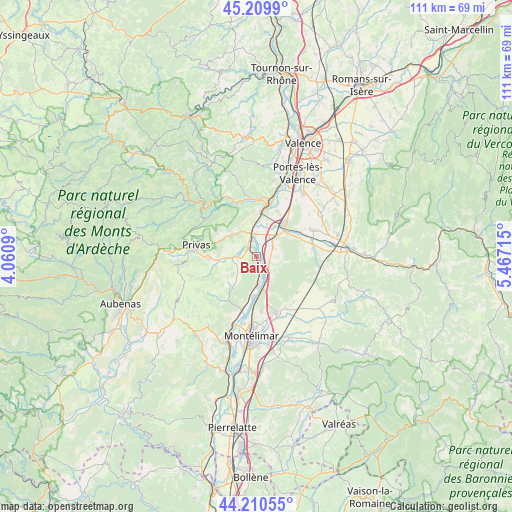
Baix GPS coordinates[2]
44° 42' 44.568" North, 4° 45' 50.508" East
| Map corner | latitude | longitude |
|---|---|---|
| Upper-left | 45.2099°, | 4.0609° |
| Center: | 44.71238°, | 4.76403° |
| Lower-right: | 44.21055°, | 5.46715° |
| Map W x H: | 111.1×111.1 km | = 69×69mi |
| max Lat: | 51.07786° ⇑82% North |
| Baix: | 44.71238° |
| min Lat: | ⇓18% South 41.3874° |
| min Long | Baix | max Long |
| -5.08615° | 4.76403° | 9.52242° |
| W 74.6%⇐ | ⇒25.4% E |
Elevation
Elevation of Baix is 88 m = 289 ft, and this is 105.7 m = 347 ft below average elevation for this country.
| Max E: |
2333 m = 7654 ft | 65.6% |
| Avg. | 193.7 m = 635 ft | |
| Baix | 88 m = 289 ft | |
Min E: |
-1 m = -3 ft | 34.4% |
See also: France elevation on elevation.city.
Geographical zone
Baix is located in North temperate zone (between Tropic of Cancer and the Arctic Circle). Distance of this Northern Tropic circle is 2365.6 km =1469.9 mi to South.| Distance of | km | miles | from Baix |
|---|---|---|---|
| North Pole | 5035.5 | 3128.9 | to North |
| Arctic Circle | 2429.6 | 1509.7 | to North |
| Tropic Cancer | 2365.6 | 1469.9 | to South |
| Equator | 4971.6 | 3089.2 | to South |


Nearby cities:
15 places around Baix: (largest is in red/bold)
• Chomérac
8.1 km =5 mi,  266°
266°
• Cliousclat
5.4 km =3.4 mi,  84°
84°
• Cruas
6.2 km =3.9 mi,  180°
180°
• Flaviac
8.1 km =5 mi,  299°
299°
• La Coucourde
7.2 km =4.5 mi,  167°
167°
• Le Pouzin
4.6 km =2.9 mi,  343°
343°
• Livron-sur-Drôme
9.4 km =5.8 mi,  40°
40°
• Loriol-sur-Drôme
5.7 km =3.5 mi,  47°
47°
• Mirmande
5.8 km =3.6 mi,  105°
105°
• Rompon
7.4 km =4.6 mi, 340°
• Saint-Julien-en-Saint-Alban
7.1 km =4.4 mi,  311°
311°
• Saint-Lager-Bressac
4.8 km =3 mi,  242°
242°
• Saint-Symphorien-sous-Chomérac
4.8 km =3 mi,  279°
279°
• Saint-Vincent-de-Barrès
7.1 km =4.4 mi,  217°
217°
• Saulce-sur-Rhône
3 km =1.9 mi, 107°
Sources, notices
• [Note1] Compared only with cities in France existing in our database
• [Src1] Map data: © OpenStreetMap contributors (CC-BY-SA)
• [Src2] Other city data from geonames.org with taken over terms of usage.
• [Src3] Geographical zone / Annual Mean Temperature by Robert A. Rohde @ Wikipedia
