Loriol-sur-Drôme geodata
Loriol-sur-Drôme (Auvergne-Rhône-Alpes) is a populated place; located in France in Europe/Paris (GMT+2) time zone. With population of 5,803 people, there are 1699 cities with bigger population in this country. Compared to other cities in France, 81.8% of cities are located further ↑North; 75.3% of cities are located further ←West and 63.1% of cities have lower elevation than Loriol-sur-Drôme. Note1
Administrative division(s):
- Level 1: Auvergne-Rhône-Alpes
- Level 2: Département de la Drôme
- Level 3: Arrondissement de Die
- Level 4: Loriol-sur-Drôme


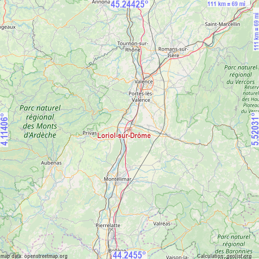
Loriol-sur-Drôme GPS coordinates[2]
44° 44' 49.308" North, 4° 49' 1.884" East
| Map corner | latitude | longitude |
|---|---|---|
| Upper-left | 45.24425°, | 4.11406° |
| Center: | 44.74703°, | 4.81719° |
| Lower-right: | 44.2455°, | 5.52031° |
| Map W x H: | 111.1×111 km | = 69×69mi |
| max Lat: | 51.07786° ⇑81.8% North |
| Loriol-sur-Drôme: | 44.74703° |
| min Lat: | ⇓18.2% South 41.3874° |
| min Long | Loriol-sur-Drô | max Long |
| -5.08615° | 4.81719° | 9.52242° |
| W 75.3%⇐ | ⇒24.7% E |
Elevation
Elevation of Loriol-sur-Drôme is 185 m = 607 ft, and this is 8.7 m = 29 ft below average elevation for this country.
| Max E: |
2333 m = 7654 ft | 36.9% |
| Avg. | 193.7 m = 635 ft | |
| Loriol-sur-Drôme | 185 m = 607 ft | |
Min E: |
-1 m = -3 ft | 63.1% |
See also: France elevation on elevation.city.
Geographical zone
Loriol-sur-Drôme is located in North temperate zone (between Tropic of Cancer and the Arctic Circle). Distance of this Northern Tropic circle is 2369.5 km =1472.3 mi to South.| Distance of | km | miles | from Loriol-sur-Drôme |
|---|---|---|---|
| North Pole | 5031.7 | 3126.6 | to North |
| Arctic Circle | 2425.8 | 1507.3 | to North |
| Tropic Cancer | 2369.5 | 1472.3 | to South |
| Equator | 4975.4 | 3091.6 | to South |


Nearby cities:
15 places around Loriol-sur-Drôme: (largest is in red/bold)
• Allex
6.8 km =4.2 mi,  70°
70°
• Baix
5.7 km =3.5 mi,  227°
227°
• Beauchastel
8.8 km =5.5 mi,  352°
352°
• Chabrillan
10.1 km =6.3 mi,  105°
105°
• Cliousclat
3.5 km =2.2 mi,  160°
160°
• Grane
8.4 km =5.2 mi,  101°
101°
• La Voulte-sur-Rhône
6.6 km =4.1 mi,  332°
332°
• Le Pouzin
5.5 km =3.4 mi,  275°
275°
• Livron-sur-Drôme
3.8 km =2.4 mi,  30°
30°
• Mirmande
5.5 km =3.4 mi,  165°
165°
• Rompon
7.4 km =4.6 mi,  294°
294°
• Saint-Julien-en-Saint-Alban
9.5 km =5.9 mi,  274°
274°
• Saint-Laurent-du-Pape
9.4 km =5.8 mi, 334°
• Saint-Symphorien-sous-Chomérac
9.4 km =5.8 mi,  250°
250°
• Saulce-sur-Rhône
4.9 km =3 mi,  195°
195°
Sources, notices
• [Note1] Compared only with cities in France existing in our database
• [Src1] Map data: © OpenStreetMap contributors (CC-BY-SA)
• [Src2] Other city data from geonames.org with taken over terms of usage.
• [Src3] Geographical zone / Annual Mean Temperature by Robert A. Rohde @ Wikipedia
