Bais geodata
Bais (Pays de la Loire) is a populated place; located in France in Europe/Paris (GMT+2) time zone. With population of 1,568 people, there are 5943 cities with bigger population in this country. Compared to other cities in France, 63.7% of cities are located further ↓South; 81.6% of cities are located further →East and 63.3% of cities have lower elevation than Bais. Note1
Administrative division(s):
- Level 1: Pays de la Loire
- Level 2: Mayenne
- Level 3: Arrondissement de Mayenne
- Level 4: Bais


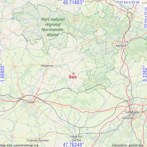
Bais GPS coordinates[2]
48° 15' 10.08" North, 0° 21' 53.748" West
| Map corner | latitude | longitude |
|---|---|---|
| Upper-left | 48.71883°, | -1.06805° |
| Center: | 48.2528°, | -0.36493° |
| Lower-right: | 47.78248°, | 0.3382° |
| Map W x H: | 104.1×104.1 km | = 64.7×64.7mi |
| max Lat: | 51.07786° ⇑36.3% North |
| Bais: | 48.2528° |
| min Lat: | ⇓63.7% South 41.3874° |
| min Long | Bais | max Long |
| -5.08615° | -0.36493° | 9.52242° |
| W 18.4%⇐ | ⇒81.6% E |
Elevation
Elevation of Bais is 186 m = 610 ft, and this is 7.7 m = 25 ft below average elevation for this country.
| Max E: |
2333 m = 7654 ft | 36.7% |
| Avg. | 193.7 m = 635 ft | |
| Bais | 186 m = 610 ft | |
Min E: |
-1 m = -3 ft | 63.3% |
See also: France elevation on elevation.city.
Geographical zone
Bais is located in North temperate zone (between Tropic of Cancer and the Arctic Circle). Distance of this North polar circle is 2036 km =1265.1 mi to North.| Distance of | km | miles | from Bais |
|---|---|---|---|
| North Pole | 4641.9 | 2884.3 | to North |
| Arctic Circle | 2036 | 1265.1 | to North |
| Tropic Cancer | 2759.3 | 1714.5 | to South |
| Equator | 5365.2 | 3333.8 | to South |


Nearby cities:
15 places around Bais: (largest is in red/bold)
• Averton
13.7 km =8.5 mi,  50°
50°
• Champgenéteux
4.3 km =2.7 mi,  2°
2°
• Châtres-la-Forêt
14.1 km =8.8 mi,  200°
200°
• Courcité
10.4 km =6.5 mi,  55°
55°
• Grazay
9.5 km =5.9 mi,  295°
295°
• Hambers
4 km =2.5 mi,  272°
272°
• Jublains
9.7 km =6 mi, 271°
• Marcillé-la-Ville
11.3 km =7 mi, 301°
• Mézangers
8.4 km =5.2 mi,  214°
214°
• Neau
13.6 km =8.5 mi,  217°
217°
• Saint-Pierre-sur-Orthe
12.6 km =7.8 mi,  111°
111°
• Sainte-Gemmes-le-Robert
6.5 km =4 mi,  187°
187°
• Villaines-la-Juhel
12 km =7.5 mi,  32°
32°
• Voutré
14 km =8.7 mi,  157°
157°
• Évron
11 km =6.8 mi, 193°
Sources, notices
• [Note1] Compared only with cities in France existing in our database
• [Src1] Map data: © OpenStreetMap contributors (CC-BY-SA)
• [Src2] Other city data from geonames.org with taken over terms of usage.
• [Src3] Geographical zone / Annual Mean Temperature by Robert A. Rohde @ Wikipedia
