Champgenéteux geodata
Champgenéteux (Pays de la Loire) is a populated place; located in France in Europe/Paris (GMT+2) time zone. With population of 582 people, there are 13612 cities with bigger population in this country. Compared to other cities in France, 64.4% of cities are located further ↓South; 81.6% of cities are located further →East and 75.5% of cities have lower elevation than Champgenéteux. Note1
Administrative division(s):
- Level 1: Pays de la Loire
- Level 2: Mayenne
- Level 3: Arrondissement de Mayenne
- Level 4: Champgenéteux


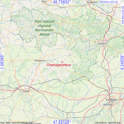
Champgenéteux GPS coordinates[2]
48° 17' 28.464" North, 0° 21' 45.216" West
| Map corner | latitude | longitude |
|---|---|---|
| Upper-left | 48.75692°, | -1.06569° |
| Center: | 48.29124°, | -0.36256° |
| Lower-right: | 47.82128°, | 0.34056° |
| Map W x H: | 104×104 km | = 64.6×64.6mi |
| max Lat: | 51.07786° ⇑35.6% North |
| Champgenéteux: | 48.29124° |
| min Lat: | ⇓64.4% South 41.3874° |
| min Long | Champgenéteux | max Long |
| -5.08615° | -0.36256° | 9.52242° |
| W 18.4%⇐ | ⇒81.6% E |
Elevation
Elevation of Champgenéteux is 253 m = 830 ft, and this is 59.3 m = 195 ft above average elevation for this country.
| Max E: |
2333 m = 7654 ft | 24.5% |
| Champgenéteux | 253 m 830 ft | |
| Avg. | 193.7 m = 635 ft | |
Min E: |
-1 m = -3 ft | 75.5% |
See also: France elevation on elevation.city.
Geographical zone
Champgenéteux is located in North temperate zone (between Tropic of Cancer and the Arctic Circle). Distance of this North polar circle is 2031.7 km =1262.4 mi to North.| Distance of | km | miles | from Champgenéteux |
|---|---|---|---|
| North Pole | 4637.6 | 2881.7 | to North |
| Arctic Circle | 2031.7 | 1262.4 | to North |
| Tropic Cancer | 2763.6 | 1717.2 | to South |
| Equator | 5369.5 | 3336.5 | to South |


Nearby cities:
15 places around Champgenéteux: (largest is in red/bold)
• Aron
14.6 km =9.1 mi,  272°
272°
• Averton
11.3 km =7 mi,  66°
66°
• Bais
4.3 km =2.7 mi,  182°
182°
• Champéon
14.3 km =8.9 mi,  306°
306°
• Courcité
8.5 km =5.3 mi,  78°
78°
• Grazay
8.7 km =5.4 mi, 269°
• Hambers
5.8 km =3.6 mi,  224°
224°
• Javron-les-Chapelles
14.2 km =8.8 mi,  7°
7°
• Jublains
10.6 km =6.6 mi,  248°
248°
• Le Horps
13.9 km =8.6 mi,  328°
328°
• Marcillé-la-Ville
9.9 km =6.2 mi,  279°
279°
• Mézangers
12.3 km =7.6 mi,  203°
203°
• Saint-Pierre-sur-Orthe
14.6 km =9.1 mi,  127°
127°
• Sainte-Gemmes-le-Robert
10.8 km =6.7 mi,  185°
185°
• Villaines-la-Juhel
8.6 km =5.3 mi,  46°
46°
Sources, notices
• [Note1] Compared only with cities in France existing in our database
• [Src1] Map data: © OpenStreetMap contributors (CC-BY-SA)
• [Src2] Other city data from geonames.org with taken over terms of usage.
• [Src3] Geographical zone / Annual Mean Temperature by Robert A. Rohde @ Wikipedia
