Avord geodata
Avord (Centre) is a populated place; located in France in Europe/Paris (GMT+2) time zone. With population of 2,957 people, there are 3296 cities with bigger population in this country. Compared to other cities in France, 54.9% of cities are located further ↑North; 52.8% of cities are located further ←West and 59.8% of cities have lower elevation than Avord. Note1
Administrative division(s):
- Level 1: Centre
- Level 2: Cher
- Level 3: Arrondissement de Bourges
- Level 4: Avord


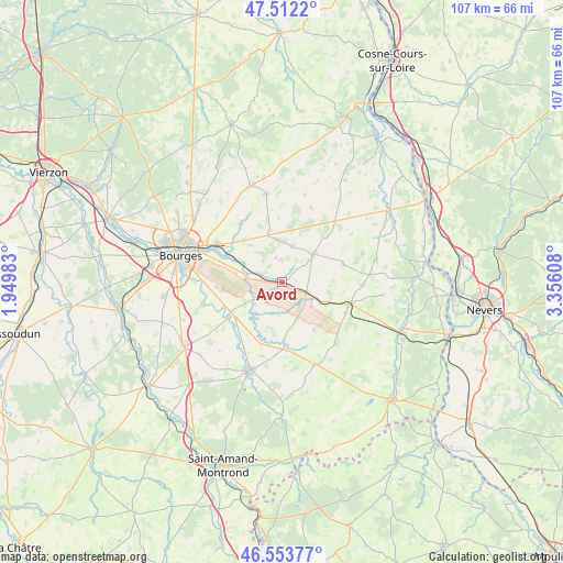
Avord GPS coordinates[2]
47° 2' 6.504" North, 2° 39' 10.62" East
| Map corner | latitude | longitude |
|---|---|---|
| Upper-left | 47.5122°, | 1.94983° |
| Center: | 47.03514°, | 2.65295° |
| Lower-right: | 46.55377°, | 3.35608° |
| Map W x H: | 106.6×106.6 km | = 66.2×66.2mi |
| max Lat: | 51.07786° ⇑54.9% North |
| Avord: | 47.03514° |
| min Lat: | ⇓45.1% South 41.3874° |
| min Long | Avord | max Long |
| -5.08615° | 2.65295° | 9.52242° |
| W 52.8%⇐ | ⇒47.2% E |
Elevation
Elevation of Avord is 169 m = 554 ft, and this is 24.7 m = 81 ft below average elevation for this country.
| Max E: |
2333 m = 7654 ft | 40.2% |
| Avg. | 193.7 m = 635 ft | |
| Avord | 169 m = 554 ft | |
Min E: |
-1 m = -3 ft | 59.8% |
See also: France elevation on elevation.city.
Geographical zone
Avord is located in North temperate zone (between Tropic of Cancer and the Arctic Circle). Distance of this North polar circle is 2171.4 km =1349.2 mi to North.| Distance of | km | miles | from Avord |
|---|---|---|---|
| North Pole | 4777.2 | 2968.4 | to North |
| Arctic Circle | 2171.4 | 1349.2 | to North |
| Tropic Cancer | 2623.9 | 1630.4 | to South |
| Equator | 5229.8 | 3249.6 | to South |


Nearby cities:
15 places around Avord: (largest is in red/bold)
• Baugy
7.7 km =4.8 mi,  47°
47°
• Bengy-sur-Craon
8 km =5 mi,  118°
118°
• Blet
16.7 km =10.4 mi,  158°
158°
• Brécy
10.2 km =6.3 mi,  345°
345°
• Dun-sur-Auron
17.8 km =11.1 mi,  199°
199°
• Farges-en-Septaine
4.3 km =2.7 mi,  357°
357°
• Nérondes
13.2 km =8.2 mi,  108°
108°
• Ourouer-les-Bourdelins
18.1 km =11.2 mi,  136°
136°
• Plaimpied-Givaudins
15.6 km =9.7 mi,  254°
254°
• Rians
16.2 km =10.1 mi, 349°
• Saint-Germain-du-Puy
14.7 km =9.1 mi,  299°
299°
• Saint-Just
11.9 km =7.4 mi, 247°
• Sainte-Solange
13.7 km =8.5 mi,  325°
325°
• Savigny-en-Septaine
7.1 km =4.4 mi,  277°
277°
• Soye-en-Septaine
12.5 km =7.8 mi,  265°
265°
Sources, notices
• [Note1] Compared only with cities in France existing in our database
• [Src1] Map data: © OpenStreetMap contributors (CC-BY-SA)
• [Src2] Other city data from geonames.org with taken over terms of usage.
• [Src3] Geographical zone / Annual Mean Temperature by Robert A. Rohde @ Wikipedia
