Plaimpied-Givaudins geodata
Plaimpied-Givaudins (Centre) is a populated place; located in France in Europe/Paris (GMT+2) time zone. With population of 1,669 people, there are 5610 cities with bigger population in this country. Compared to other cities in France, 55.3% of cities are located further ↑North; 50.1% of cities are located further →East and 55.6% of cities have lower elevation than Plaimpied-Givaudins. Note1
Administrative division(s):
- Level 1: Centre
- Level 2: Cher
- Level 3: Arrondissement de Bourges
- Level 4: Plaimpied-Givaudins


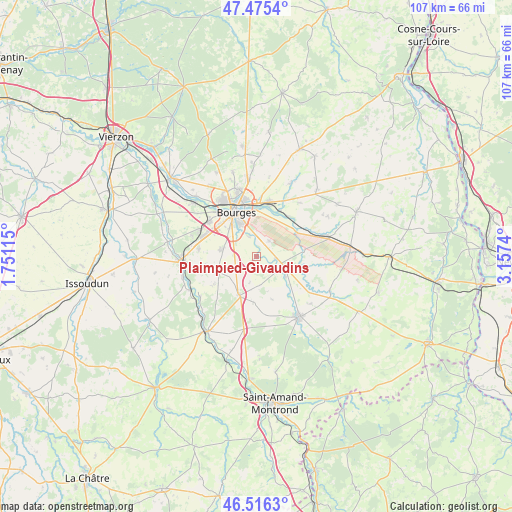
Plaimpied-Givaudins GPS coordinates[2]
46° 59' 52.8" North, 2° 27' 15.408" East
| Map corner | latitude | longitude |
|---|---|---|
| Upper-left | 47.4754°, | 1.75115° |
| Center: | 46.998°, | 2.45428° |
| Lower-right: | 46.5163°, | 3.1574° |
| Map W x H: | 106.6×106.6 km | = 66.2×66.2mi |
| max Lat: | 51.07786° ⇑55.3% North |
| Plaimpied-Givaudins: | 46.998° |
| min Lat: | ⇓44.7% South 41.3874° |
| min Long | Plaimpied-Givau | max Long |
| -5.08615° | 2.45428° | 9.52242° |
| W 49.9%⇐ | ⇒50.1% E |
Elevation
Elevation of Plaimpied-Givaudins is 152 m = 499 ft, and this is 41.7 m = 137 ft below average elevation for this country.
| Max E: |
2333 m = 7654 ft | 44.4% |
| Avg. | 193.7 m = 635 ft | |
| Plaimpied-Givaudins | 152 m = 499 ft | |
Min E: |
-1 m = -3 ft | 55.6% |
See also: France elevation on elevation.city.
Geographical zone
Plaimpied-Givaudins is located in North temperate zone (between Tropic of Cancer and the Arctic Circle). Distance of this North polar circle is 2175.5 km =1351.8 mi to North.| Distance of | km | miles | from Plaimpied-Givaudins |
|---|---|---|---|
| North Pole | 4781.4 | 2971 | to North |
| Arctic Circle | 2175.5 | 1351.8 | to North |
| Tropic Cancer | 2619.8 | 1627.9 | to South |
| Equator | 5225.7 | 3247.1 | to South |


Nearby cities:
15 places around Plaimpied-Givaudins: (largest is in red/bold)
• Avord
15.6 km =9.7 mi,  74°
74°
• Bourges
10.3 km =6.4 mi,  336°
336°
• Dun-sur-Auron
15.5 km =9.6 mi,  144°
144°
• La Chapelle-Saint-Ursin
12.2 km =7.6 mi,  306°
306°
• Le Subdray
12.2 km =7.6 mi,  277°
277°
• Levet
8.8 km =5.5 mi,  204°
204°
• Morthomiers
14.3 km =8.9 mi,  287°
287°
• Saint-Doulchard
14.1 km =8.8 mi,  326°
326°
• Saint-Florent-sur-Cher
15.4 km =9.6 mi,  268°
268°
• Saint-Germain-des-Bois
9.5 km =5.9 mi,  184°
184°
• Saint-Germain-du-Puy
11.6 km =7.2 mi,  10°
10°
• Saint-Just
4.1 km =2.5 mi,  96°
96°
• Savigny-en-Septaine
9.5 km =5.9 mi,  57°
57°
• Soye-en-Septaine
4.2 km =2.6 mi,  38°
38°
• Trouy
7.3 km =4.5 mi, 281°
Sources, notices
• [Note1] Compared only with cities in France existing in our database
• [Src1] Map data: © OpenStreetMap contributors (CC-BY-SA)
• [Src2] Other city data from geonames.org with taken over terms of usage.
• [Src3] Geographical zone / Annual Mean Temperature by Robert A. Rohde @ Wikipedia
