Giat geodata
Giat (Auvergne-Rhône-Alpes) is a populated place; located in France in Europe/Paris (GMT+2) time zone. With population of 891 people, there are 9734 cities with bigger population in this country. Compared to other cities in France, 69.2% of cities are located further ↑North; 50.1% of cities are located further ←West and 97.3% of cities have lower elevation than Giat. Note1
Administrative division(s):
- Level 1: Auvergne-Rhône-Alpes
- Level 2: Département du Puy-de-Dôme
- Level 3: Arrondissement de Riom
- Level 4: Giat


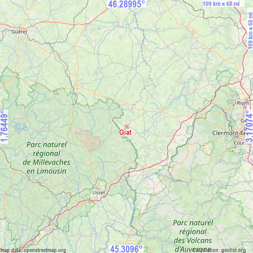
Giat GPS coordinates[2]
45° 48' 6.948" North, 2° 28' 3.396" East
| Map corner | latitude | longitude |
|---|---|---|
| Upper-left | 46.28995°, | 1.76449° |
| Center: | 45.80193°, | 2.46761° |
| Lower-right: | 45.3096°, | 3.17074° |
| Map W x H: | 109×109 km | = 67.7×67.7mi |
| max Lat: | 51.07786° ⇑69.2% North |
| Giat: | 45.80193° |
| min Lat: | ⇓30.8% South 41.3874° |
| min Long | Giat | max Long |
| -5.08615° | 2.46761° | 9.52242° |
| W 50.1%⇐ | ⇒49.9% E |
Elevation
Elevation of Giat is 749 m = 2457 ft, and this is 555.3 m = 1822 ft above average elevation for this country.
| Max E: |
2333 m = 7654 ft | 2.7% |
| Giat | 749 m 2457 ft | |
| Avg. | 193.7 m = 635 ft | |
Min E: |
-1 m = -3 ft | 97.3% |
See also: France elevation on elevation.city.
Geographical zone
Giat is located in North temperate zone (between Tropic of Cancer and the Arctic Circle). Distance of this North polar circle is 2308.5 km =1434.4 mi to North.| Distance of | km | miles | from Giat |
|---|---|---|---|
| North Pole | 4914.4 | 3053.7 | to North |
| Arctic Circle | 2308.5 | 1434.4 | to North |
| Tropic Cancer | 2486.8 | 1545.2 | to South |
| Equator | 5092.7 | 3164.5 | to South |


Nearby cities:
15 places around Giat: (largest is in red/bold)
• Auzances
25.3 km =15.7 mi,  5°
5°
• Bourg-Lastic
18.6 km =11.6 mi,  157°
157°
• Charensat
24.3 km =15.1 mi,  32°
32°
• Crocq
10.6 km =6.6 mi,  313°
313°
• Eygurande
15.7 km =9.8 mi,  184°
184°
• Felletin
24.6 km =15.3 mi,  291°
291°
• Gelles
23.2 km =14.4 mi,  98°
98°
• La Courtine
19.4 km =12.1 mi,  234°
234°
• La Goutelle
23 km =14.3 mi,  78°
78°
• Merlines
18.7 km =11.6 mi, 180°
• Messeix
21.3 km =13.2 mi, 164°
• Mérinchal
12.9 km =8 mi, 7°
• Pontaumur
17.7 km =11 mi,  65°
65°
• Saint-Sauves-d'Auvergne
28 km =17.4 mi,  143°
143°
• Sornac
26 km =16.2 mi, 234°
Sources, notices
• [Note1] Compared only with cities in France existing in our database
• [Src1] Map data: © OpenStreetMap contributors (CC-BY-SA)
• [Src2] Other city data from geonames.org with taken over terms of usage.
• [Src3] Geographical zone / Annual Mean Temperature by Robert A. Rohde @ Wikipedia
