Auxi-le-Château geodata
Auxi-le-Château (Hauts-de-France) is a populated place; located in France in Europe/Paris (GMT+2) time zone. With population of 2,969 people, there are 3285 cities with bigger population in this country. Compared to other cities in France, 95% of cities are located further ↓South; 55.6% of cities are located further →East and 89.1% of cities have higher elevation than Auxi-le-Château. Note1
Administrative division(s):
- Level 1: Hauts-de-France
- Level 2: Pas-de-Calais
- Level 3: Arras
- Level 4: Auxi-le-Château


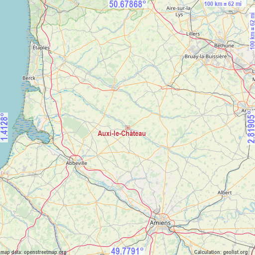
Auxi-le-Château GPS coordinates[2]
50° 13' 51.636" North, 2° 6' 57.348" East
| Map corner | latitude | longitude |
|---|---|---|
| Upper-left | 50.67868°, | 1.4128° |
| Center: | 50.23101°, | 2.11593° |
| Lower-right: | 49.7791°, | 2.81905° |
| Map W x H: | 100×100 km | = 62.1×62.1mi |
| max Lat: | 51.07786° ⇑5% North |
| Auxi-le-Château: | 50.23101° |
| min Lat: | ⇓95% South 41.3874° |
| min Long | Auxi-le-Châtea | max Long |
| -5.08615° | 2.11593° | 9.52242° |
| W 44.4%⇐ | ⇒55.6% E |
Elevation
Elevation of Auxi-le-Château is 32 m = 105 ft, and this is 161.7 m = 531 ft below average elevation for this country.
| Max E: |
2333 m = 7654 ft | 89.1% |
| Avg. | 193.7 m = 635 ft | |
| Auxi-le-Château | 32 m = 105 ft | |
Min E: |
-1 m = -3 ft | 10.9% |
See also: France elevation on elevation.city.
Geographical zone
Auxi-le-Château is located in North temperate zone (between Tropic of Cancer and the Arctic Circle). Distance of this North polar circle is 1816 km =1128.4 mi to North.| Distance of | km | miles | from Auxi-le-Château |
|---|---|---|---|
| North Pole | 4421.9 | 2747.6 | to North |
| Arctic Circle | 1816 | 1128.4 | to North |
| Tropic Cancer | 2979.2 | 1851.2 | to South |
| Equator | 5585.2 | 3470.5 | to South |


Nearby cities:
15 places around Auxi-le-Château: (largest is in red/bold)
• Bernaville
11.5 km =7.1 mi,  163°
163°
• Bonnières
10.4 km =6.5 mi,  82°
82°
• Boubers-sur-Canche
10.8 km =6.7 mi,  52°
52°
• Candas
17.2 km =10.7 mi,  143°
143°
• Crécy-en-Ponthieu
16.9 km =10.5 mi,  277°
277°
• Domart-en-Ponthieu
17.4 km =10.8 mi,  177°
177°
• Fienvillers
14.9 km =9.3 mi,  147°
147°
• Fillièvres
10 km =6.2 mi,  17°
17°
• Frévent
13.2 km =8.2 mi,  67°
67°
• Hesdin
16.8 km =10.4 mi,  340°
340°
• Huby-Saint-Leu
17.7 km =11 mi, 341°
• Le Parcq
16.5 km =10.3 mi,  355°
355°
• Marconne
16.4 km =10.2 mi, 342°
• Marconnelle
17.7 km =11 mi, 335°
• Saint-Riquier
16.3 km =10.1 mi,  227°
227°
Sources, notices
• [Note1] Compared only with cities in France existing in our database
• [Src1] Map data: © OpenStreetMap contributors (CC-BY-SA)
• [Src2] Other city data from geonames.org with taken over terms of usage.
• [Src3] Geographical zone / Annual Mean Temperature by Robert A. Rohde @ Wikipedia
