Domart-en-Ponthieu geodata
Domart-en-Ponthieu (Hauts-de-France) is a populated place; located in France in Europe/Paris (GMT+2) time zone. With population of 1,140 people, there are 7890 cities with bigger population in this country. Compared to other cities in France, 94% of cities are located further ↓South; 55.4% of cities are located further →East and 79.4% of cities have higher elevation than Domart-en-Ponthieu. Note1
Administrative division(s):
- Level 1: Hauts-de-France
- Level 2: Somme
- Level 3: Amiens
- Level 4: Domart-en-Ponthieu


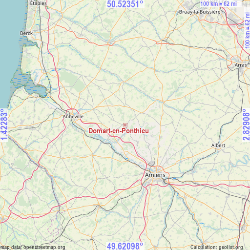
Domart-en-Ponthieu GPS coordinates[2]
50° 4' 27.732" North, 2° 7' 33.456" East
| Map corner | latitude | longitude |
|---|---|---|
| Upper-left | 50.52351°, | 1.42283° |
| Center: | 50.07437°, | 2.12596° |
| Lower-right: | 49.62098°, | 2.82908° |
| Map W x H: | 100.4×100.3 km | = 62.4×62.3mi |
| max Lat: | 51.07786° ⇑6% North |
| Domart-en-Ponthieu: | 50.07437° |
| min Lat: | ⇓94% South 41.3874° |
| min Long | Domart-en-Ponth | max Long |
| -5.08615° | 2.12596° | 9.52242° |
| W 44.6%⇐ | ⇒55.4% E |
Elevation
Elevation of Domart-en-Ponthieu is 56 m = 184 ft, and this is 137.7 m = 452 ft below average elevation for this country.
| Max E: |
2333 m = 7654 ft | 79.4% |
| Avg. | 193.7 m = 635 ft | |
| Domart-en-Ponthieu | 56 m = 184 ft | |
Min E: |
-1 m = -3 ft | 20.6% |
See also: France elevation on elevation.city.
Geographical zone
Domart-en-Ponthieu is located in North temperate zone (between Tropic of Cancer and the Arctic Circle). Distance of this North polar circle is 1833.4 km =1139.2 mi to North.| Distance of | km | miles | from Domart-en-Ponthieu |
|---|---|---|---|
| North Pole | 4439.3 | 2758.5 | to North |
| Arctic Circle | 1833.4 | 1139.2 | to North |
| Tropic Cancer | 2961.8 | 1840.4 | to South |
| Equator | 5567.7 | 3459.6 | to South |


Nearby cities:
15 places around Domart-en-Ponthieu: (largest is in red/bold)
• Ailly-le-Haut-Clocher
9.4 km =5.8 mi,  273°
273°
• Bernaville
7 km =4.3 mi,  22°
22°
• Berteaucourt-les-Dames
3.8 km =2.4 mi,  143°
143°
• Canaples
6.9 km =4.3 mi,  107°
107°
• Candas
10.2 km =6.3 mi,  69°
69°
• Condé-Folie
10.9 km =6.8 mi,  228°
228°
• Fienvillers
8.8 km =5.5 mi,  56°
56°
• Flixecourt
7.4 km =4.6 mi,  205°
205°
• Hangest-sur-Somme
11.3 km =7 mi,  202°
202°
• Long
11.1 km =6.9 mi,  250°
250°
• Naours
11.6 km =7.2 mi, 111°
• Pernois
5 km =3.1 mi,  118°
118°
• Saint-Léger-lès-Domart
2.7 km =1.7 mi,  157°
157°
• Saint-Ouen
4 km =2.5 mi,  185°
185°
• Vignacourt
8.6 km =5.3 mi, 143°
Sources, notices
• [Note1] Compared only with cities in France existing in our database
• [Src1] Map data: © OpenStreetMap contributors (CC-BY-SA)
• [Src2] Other city data from geonames.org with taken over terms of usage.
• [Src3] Geographical zone / Annual Mean Temperature by Robert A. Rohde @ Wikipedia
