Boubers-sur-Canche geodata
Boubers-sur-Canche (Hauts-de-France) is a populated place; located in France in Europe/Paris (GMT+2) time zone. With population of 624 people, there are 12917 cities with bigger population in this country. Compared to other cities in France, 95.4% of cities are located further ↓South; 53.8% of cities are located further →East and 79% of cities have higher elevation than Boubers-sur-Canche. Note1
Administrative division(s):
- Level 1: Hauts-de-France
- Level 2: Pas-de-Calais
- Level 3: Arras
- Level 4: Boubers-sur-Canche


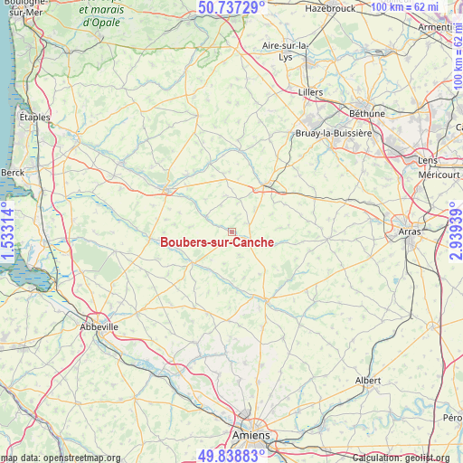
Boubers-sur-Canche GPS coordinates[2]
50° 17' 24.648" North, 2° 14' 10.572" East
| Map corner | latitude | longitude |
|---|---|---|
| Upper-left | 50.73729°, | 1.53314° |
| Center: | 50.29018°, | 2.23627° |
| Lower-right: | 49.83883°, | 2.93939° |
| Map W x H: | 99.9×99.9 km | = 62.1×62.1mi |
| max Lat: | 51.07786° ⇑4.6% North |
| Boubers-sur-Canche: | 50.29018° |
| min Lat: | ⇓95.4% South 41.3874° |
| min Long | Boubers-sur-Can | max Long |
| -5.08615° | 2.23627° | 9.52242° |
| W 46.2%⇐ | ⇒53.8% E |
Elevation
Elevation of Boubers-sur-Canche is 57 m = 187 ft, and this is 136.7 m = 448 ft below average elevation for this country.
| Max E: |
2333 m = 7654 ft | 79% |
| Avg. | 193.7 m = 635 ft | |
| Boubers-sur-Canche | 57 m = 187 ft | |
Min E: |
-1 m = -3 ft | 21% |
See also: France elevation on elevation.city.
Geographical zone
Boubers-sur-Canche is located in North temperate zone (between Tropic of Cancer and the Arctic Circle). Distance of this North polar circle is 1809.4 km =1124.3 mi to North.| Distance of | km | miles | from Boubers-sur-Canche |
|---|---|---|---|
| North Pole | 4415.3 | 2743.5 | to North |
| Arctic Circle | 1809.4 | 1124.3 | to North |
| Tropic Cancer | 2985.8 | 1855.3 | to South |
| Equator | 5591.7 | 3474.5 | to South |


Nearby cities:
15 places around Boubers-sur-Canche: (largest is in red/bold)
• Anvin
17.4 km =10.8 mi,  4°
4°
• Auchy-lès-Hesdin
15.6 km =9.7 mi,  322°
322°
• Auxi-le-Château
10.8 km =6.7 mi,  232°
232°
• Blangy-sur-Ternoise
15.4 km =9.6 mi,  341°
341°
• Bonnières
5.5 km =3.4 mi,  161°
161°
• Doullens
16.5 km =10.3 mi,  153°
153°
• Fillièvres
6.3 km =3.9 mi,  298°
298°
• Frévent
3.9 km =2.4 mi,  113°
113°
• Gauchin-Verloingt
12.9 km =8 mi,  24°
24°
• Hesdin
16.8 km =10.4 mi, 303°
• Le Parcq
13.9 km =8.6 mi, 315°
• Lucheux
16.3 km =10.1 mi,  129°
129°
• Marconne
16.2 km =10.1 mi, 303°
• Roëllecourt
13.8 km =8.6 mi,  50°
50°
• Saint-Pol-sur-Ternoise
12.3 km =7.6 mi,  34°
34°
Sources, notices
• [Note1] Compared only with cities in France existing in our database
• [Src1] Map data: © OpenStreetMap contributors (CC-BY-SA)
• [Src2] Other city data from geonames.org with taken over terms of usage.
• [Src3] Geographical zone / Annual Mean Temperature by Robert A. Rohde @ Wikipedia
