Auxonne geodata
Auxonne (Bourgogne-Franche-Comté) is a populated place; located in France in Europe/Paris (GMT+2) time zone. With population of 7,958 people, there are 1219 cities with bigger population in this country. Compared to other cities in France, 53.1% of cities are located further ↑North; 81.7% of cities are located further ←West and 64% of cities have lower elevation than Auxonne. Note1
Administrative division(s):
- Level 1: Bourgogne-Franche-Comté
- Level 2: Département de la Côte-d'Or
- Level 3: Arrondissement de Dijon
- Level 4: Auxonne


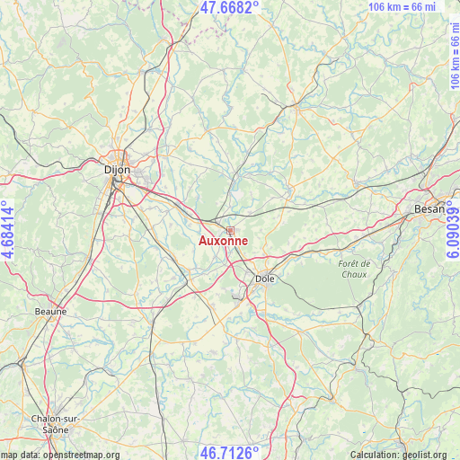
Auxonne GPS coordinates[2]
47° 11' 33.18" North, 5° 23' 14.136" East
| Map corner | latitude | longitude |
|---|---|---|
| Upper-left | 47.6682°, | 4.68414° |
| Center: | 47.19255°, | 5.38726° |
| Lower-right: | 46.7126°, | 6.09039° |
| Map W x H: | 106.3×106.3 km | = 66.1×66.1mi |
| max Lat: | 51.07786° ⇑53.1% North |
| Auxonne: | 47.19255° |
| min Lat: | ⇓46.9% South 41.3874° |
| min Long | Auxonne | max Long |
| -5.08615° | 5.38726° | 9.52242° |
| W 81.7%⇐ | ⇒18.3% E |
Elevation
Elevation of Auxonne is 189 m = 620 ft, and this is 4.7 m = 15 ft below average elevation for this country.
| Max E: |
2333 m = 7654 ft | 36% |
| Avg. | 193.7 m = 635 ft | |
| Auxonne | 189 m = 620 ft | |
Min E: |
-1 m = -3 ft | 64% |
See also: France elevation on elevation.city.
Geographical zone
Auxonne is located in North temperate zone (between Tropic of Cancer and the Arctic Circle). Distance of this North polar circle is 2153.9 km =1338.4 mi to North.| Distance of | km | miles | from Auxonne |
|---|---|---|---|
| North Pole | 4759.7 | 2957.5 | to North |
| Arctic Circle | 2153.9 | 1338.4 | to North |
| Tropic Cancer | 2641.4 | 1641.3 | to South |
| Equator | 5247.3 | 3260.5 | to South |


Nearby cities:
15 places around Auxonne: (largest is in red/bold)
• Athée
4.3 km =2.7 mi,  345°
345°
• Authume
11.3 km =7 mi,  129°
129°
• Champdôtre
6.4 km =4 mi,  259°
259°
• Champvans
10.5 km =6.5 mi,  158°
158°
• Collonges-lès-Premières
9.8 km =6.1 mi,  291°
291°
• Lamarche-sur-Saône
8.6 km =5.3 mi,  359°
359°
• Les Maillys
7.3 km =4.5 mi,  209°
209°
• Longchamp
10.6 km =6.6 mi,  314°
314°
• Longeault
10.6 km =6.6 mi, 287°
• Moissey
10.3 km =6.4 mi,  87°
87°
• Pluvault
10.3 km =6.4 mi,  282°
282°
• Sampans
9.1 km =5.7 mi,  144°
144°
• Tillenay
3.2 km =2 mi,  241°
241°
• Trouhans
9.8 km =6.1 mi, 240°
• Villers-les-Pots
3.9 km =2.4 mi, 313°
Sources, notices
• [Note1] Compared only with cities in France existing in our database
• [Src1] Map data: © OpenStreetMap contributors (CC-BY-SA)
• [Src2] Other city data from geonames.org with taken over terms of usage.
• [Src3] Geographical zone / Annual Mean Temperature by Robert A. Rohde @ Wikipedia
