Augy geodata
Augy (Bourgogne-Franche-Comté) is a populated place; located in France in Europe/Paris (GMT+2) time zone. With population of 1,182 people, there are 7635 cities with bigger population in this country. Compared to other cities in France, 55.3% of cities are located further ↓South; 65.1% of cities are located further ←West and 60.8% of cities have higher elevation than Augy. Note1
Administrative division(s):
- Level 1: Bourgogne-Franche-Comté
- Level 2: Département de l'Yonne
- Level 3: Auxerre
- Level 4: Augy


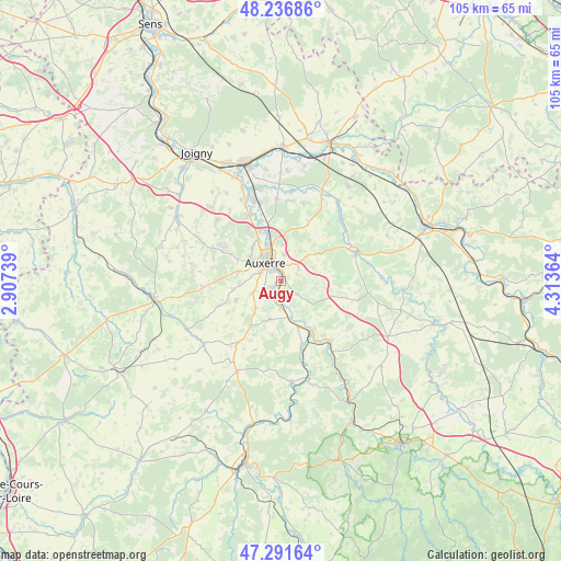
Augy GPS coordinates[2]
47° 45' 59.04" North, 3° 36' 37.836" East
| Map corner | latitude | longitude |
|---|---|---|
| Upper-left | 48.23686°, | 2.90739° |
| Center: | 47.7664°, | 3.61051° |
| Lower-right: | 47.29164°, | 4.31364° |
| Map W x H: | 105.1×105.1 km | = 65.3×65.3mi |
| max Lat: | 51.07786° ⇑44.7% North |
| Augy: | 47.7664° |
| min Lat: | ⇓55.3% South 41.3874° |
| min Long | Augy | max Long |
| -5.08615° | 3.61051° | 9.52242° |
| W 65.1%⇐ | ⇒34.9% E |
Elevation
Elevation of Augy is 100 m = 328 ft, and this is 93.7 m = 307 ft below average elevation for this country.
| Max E: |
2333 m = 7654 ft | 60.8% |
| Avg. | 193.7 m = 635 ft | |
| Augy | 100 m = 328 ft | |
Min E: |
-1 m = -3 ft | 39.2% |
See also: France elevation on elevation.city.
Geographical zone
Augy is located in North temperate zone (between Tropic of Cancer and the Arctic Circle). Distance of this North polar circle is 2090 km =1298.7 mi to North.| Distance of | km | miles | from Augy |
|---|---|---|---|
| North Pole | 4695.9 | 2917.9 | to North |
| Arctic Circle | 2090 | 1298.7 | to North |
| Tropic Cancer | 2705.2 | 1680.9 | to South |
| Equator | 5311.1 | 3300.2 | to South |


Nearby cities:
15 places around Augy: (largest is in red/bold)
• Auxerre
4.8 km =3 mi,  320°
320°
• Champs-sur-Yonne
3.8 km =2.4 mi,  192°
192°
• Coulanges-la-Vineuse
7.6 km =4.7 mi,  196°
196°
• Cravant
11 km =6.8 mi,  146°
146°
• Escamps
11 km =6.8 mi,  247°
247°
• Escolives-Sainte-Camille
5.4 km =3.4 mi,  182°
182°
• Gurgy
11.7 km =7.3 mi,  342°
342°
• Montigny-la-Resle
12.2 km =7.6 mi,  25°
25°
• Monéteau
9.5 km =5.9 mi,  346°
346°
• Saint-Bris-le-Vineux
3.8 km =2.4 mi,  130°
130°
• Saint-Georges-sur-Baulche
7 km =4.3 mi,  302°
302°
• Vallan
5.9 km =3.7 mi, 245°
• Venoy
4.7 km =2.9 mi,  24°
24°
• Villefargeau
8.2 km =5.1 mi,  281°
281°
• Vincelles
7.3 km =4.5 mi,  166°
166°
Sources, notices
• [Note1] Compared only with cities in France existing in our database
• [Src1] Map data: © OpenStreetMap contributors (CC-BY-SA)
• [Src2] Other city data from geonames.org with taken over terms of usage.
• [Src3] Geographical zone / Annual Mean Temperature by Robert A. Rohde @ Wikipedia
