Vallan geodata
Vallan (Bourgogne-Franche-Comté) is a populated place; located in France in Europe/Paris (GMT+2) time zone. With population of 763 people, there are 11026 cities with bigger population in this country. Compared to other cities in France, 54.9% of cities are located further ↓South; 64.6% of cities are located further ←West and 55.6% of cities have lower elevation than Vallan. Note1
Administrative division(s):
- Level 1: Bourgogne-Franche-Comté
- Level 2: Département de l'Yonne
- Level 3: Auxerre
- Level 4: Vallan


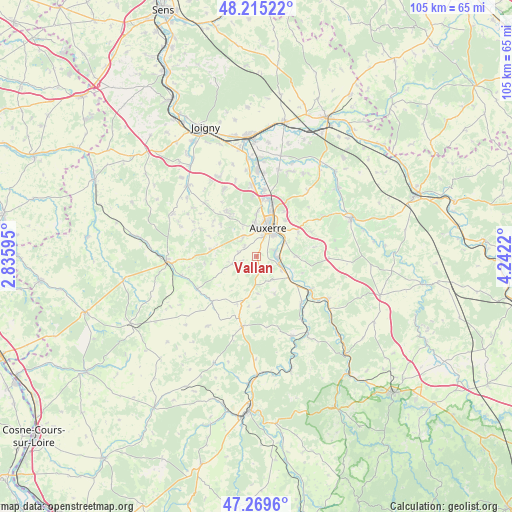
Vallan GPS coordinates[2]
47° 44' 40.416" North, 3° 32' 20.652" East
| Map corner | latitude | longitude |
|---|---|---|
| Upper-left | 48.21522°, | 2.83595° |
| Center: | 47.74456°, | 3.53907° |
| Lower-right: | 47.2696°, | 4.2422° |
| Map W x H: | 105.1×105.1 km | = 65.3×65.3mi |
| max Lat: | 51.07786° ⇑45.1% North |
| Vallan: | 47.74456° |
| min Lat: | ⇓54.9% South 41.3874° |
| min Long | Vallan | max Long |
| -5.08615° | 3.53907° | 9.52242° |
| W 64.6%⇐ | ⇒35.4% E |
Elevation
Elevation of Vallan is 152 m = 499 ft, and this is 41.7 m = 137 ft below average elevation for this country.
| Max E: |
2333 m = 7654 ft | 44.4% |
| Avg. | 193.7 m = 635 ft | |
| Vallan | 152 m = 499 ft | |
Min E: |
-1 m = -3 ft | 55.6% |
See also: France elevation on elevation.city.
Geographical zone
Vallan is located in North temperate zone (between Tropic of Cancer and the Arctic Circle). Distance of this North polar circle is 2092.5 km =1300.2 mi to North.| Distance of | km | miles | from Vallan |
|---|---|---|---|
| North Pole | 4698.4 | 2919.4 | to North |
| Arctic Circle | 2092.5 | 1300.2 | to North |
| Tropic Cancer | 2702.8 | 1679.4 | to South |
| Equator | 5308.7 | 3298.7 | to South |


Nearby cities:
15 places around Vallan: (largest is in red/bold)
• Augy
5.9 km =3.7 mi,  65°
65°
• Auxerre
6.6 km =4.1 mi,  20°
20°
• Champs-sur-Yonne
4.7 km =2.9 mi,  105°
105°
• Charbuy
10.3 km =6.4 mi,  327°
327°
• Coulanges-la-Vineuse
5.8 km =3.6 mi,  146°
146°
• Diges
10.7 km =6.6 mi,  260°
260°
• Escamps
5.2 km =3.2 mi,  250°
250°
• Escolives-Sainte-Camille
5.9 km =3.7 mi,  119°
119°
• Lindry
11 km =6.8 mi,  304°
304°
• Pourrain
9.6 km =6 mi,  277°
277°
• Saint-Bris-le-Vineux
8.2 km =5.1 mi,  90°
90°
• Saint-Georges-sur-Baulche
6.2 km =3.9 mi,  354°
354°
• Venoy
9.9 km =6.2 mi,  47°
47°
• Villefargeau
4.8 km =3 mi, 326°
• Vincelles
8.4 km =5.2 mi, 123°
Sources, notices
• [Note1] Compared only with cities in France existing in our database
• [Src1] Map data: © OpenStreetMap contributors (CC-BY-SA)
• [Src2] Other city data from geonames.org with taken over terms of usage.
• [Src3] Geographical zone / Annual Mean Temperature by Robert A. Rohde @ Wikipedia
