Ardon geodata
Ardon (Centre) is a populated place; located in France in Europe/Paris (GMT+2) time zone. With population of 920 people, there are 9490 cities with bigger population in this country. Compared to other cities in France, 55.4% of cities are located further ↓South; 58.6% of cities are located further →East and 57.6% of cities have higher elevation than Ardon. Note1
Administrative division(s):
- Level 1: Centre
- Level 2: Loiret
- Level 3: Arrondissement d’Orléans
- Level 4: Ardon


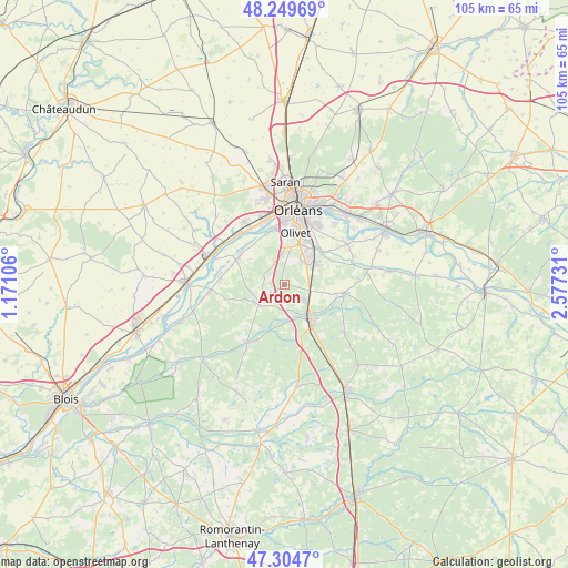
Ardon GPS coordinates[2]
47° 46' 45.624" North, 1° 52' 27.084" East
| Map corner | latitude | longitude |
|---|---|---|
| Upper-left | 48.24969°, | 1.17106° |
| Center: | 47.77934°, | 1.87419° |
| Lower-right: | 47.3047°, | 2.57731° |
| Map W x H: | 105.1×105.1 km | = 65.3×65.3mi |
| max Lat: | 51.07786° ⇑44.6% North |
| Ardon: | 47.77934° |
| min Lat: | ⇓55.4% South 41.3874° |
| min Long | Ardon | max Long |
| -5.08615° | 1.87419° | 9.52242° |
| W 41.4%⇐ | ⇒58.6% E |
Elevation
Elevation of Ardon is 109 m = 358 ft, and this is 84.7 m = 278 ft below average elevation for this country.
| Max E: |
2333 m = 7654 ft | 57.6% |
| Avg. | 193.7 m = 635 ft | |
| Ardon | 109 m = 358 ft | |
Min E: |
-1 m = -3 ft | 42.4% |
See also: France elevation on elevation.city.
Geographical zone
Ardon is located in North temperate zone (between Tropic of Cancer and the Arctic Circle). Distance of this North polar circle is 2088.6 km =1297.8 mi to North.| Distance of | km | miles | from Ardon |
|---|---|---|---|
| North Pole | 4694.5 | 2917 | to North |
| Arctic Circle | 2088.6 | 1297.8 | to North |
| Tropic Cancer | 2706.6 | 1681.8 | to South |
| Equator | 5312.6 | 3301.1 | to South |


Nearby cities:
15 places around Ardon: (largest is in red/bold)
• Cléry-Saint-André
10.4 km =6.5 mi,  297°
297°
• Dry
12.2 km =7.6 mi,  278°
278°
• Jouy-le-Potier
6 km =3.7 mi,  231°
231°
• La Chapelle-Saint-Mesmin
12.3 km =7.6 mi,  346°
346°
• La Ferté-Saint-Aubin
8.5 km =5.3 mi,  145°
145°
• Ligny-le-Ribault
12.6 km =7.8 mi,  213°
213°
• Marcilly-en-Villette
11.2 km =7 mi,  98°
98°
• Mareau-aux-Prés
11.8 km =7.3 mi,  325°
325°
• Mézières-lez-Cléry
6.7 km =4.2 mi,  308°
308°
• Olivet
9.4 km =5.8 mi,  11°
11°
• Saint-Ay
12.7 km =7.9 mi, 313°
• Saint-Cyr-en-Val
9 km =5.6 mi,  49°
49°
• Saint-Denis-en-Val
12.5 km =7.8 mi,  33°
33°
• Saint-Hilaire-Saint-Mesmin
10.1 km =6.3 mi,  342°
342°
• Saint-Pryvé-Saint-Mesmin
11.4 km =7.1 mi,  358°
358°
Sources, notices
• [Note1] Compared only with cities in France existing in our database
• [Src1] Map data: © OpenStreetMap contributors (CC-BY-SA)
• [Src2] Other city data from geonames.org with taken over terms of usage.
• [Src3] Geographical zone / Annual Mean Temperature by Robert A. Rohde @ Wikipedia
