Mareau-aux-Prés geodata
Mareau-aux-Prés (Centre) is a populated place; located in France in Europe/Paris (GMT+2) time zone. With population of 1,224 people, there are 7415 cities with bigger population in this country. Compared to other cities in France, 56.9% of cities are located further ↓South; 59.5% of cities are located further →East and 63.2% of cities have higher elevation than Mareau-aux-Prés. Note1
Administrative division(s):
- Level 1: Centre
- Level 2: Loiret
- Level 3: Arrondissement d’Orléans
- Level 4: Mareau-aux-Prés


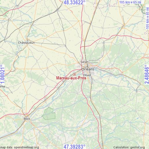
Mareau-aux-Prés GPS coordinates[2]
47° 52' 0.012" North, 1° 46' 59.988" East
| Map corner | latitude | longitude |
|---|---|---|
| Upper-left | 48.33622°, | 1.08021° |
| Center: | 47.86667°, | 1.78333° |
| Lower-right: | 47.39283°, | 2.48646° |
| Map W x H: | 104.9×104.9 km | = 65.2×65.2mi |
| max Lat: | 51.07786° ⇑43.1% North |
| Mareau-aux-Prés: | 47.86667° |
| min Lat: | ⇓56.9% South 41.3874° |
| min Long | Mareau-aux-Pré | max Long |
| -5.08615° | 1.78333° | 9.52242° |
| W 40.5%⇐ | ⇒59.5% E |
Elevation
Elevation of Mareau-aux-Prés is 94 m = 308 ft, and this is 99.7 m = 327 ft below average elevation for this country.
| Max E: |
2333 m = 7654 ft | 63.2% |
| Avg. | 193.7 m = 635 ft | |
| Mareau-aux-Prés | 94 m = 308 ft | |
Min E: |
-1 m = -3 ft | 36.8% |
See also: France elevation on elevation.city.
Geographical zone
Mareau-aux-Prés is located in North temperate zone (between Tropic of Cancer and the Arctic Circle). Distance of this North polar circle is 2078.9 km =1291.8 mi to North.| Distance of | km | miles | from Mareau-aux-Prés |
|---|---|---|---|
| North Pole | 4684.8 | 2911 | to North |
| Arctic Circle | 2078.9 | 1291.8 | to North |
| Tropic Cancer | 2716.4 | 1687.9 | to South |
| Equator | 5322.3 | 3307.1 | to South |


Nearby cities:
15 places around Mareau-aux-Prés: (largest is in red/bold)
• Chaingy
2.1 km =1.3 mi,  332°
332°
• Cléry-Saint-André
5.5 km =3.4 mi,  206°
206°
• Dry
9.4 km =5.8 mi, 213°
• Huisseau-sur-Mauves
6.7 km =4.2 mi,  296°
296°
• Ingré
6.8 km =4.2 mi,  29°
29°
• La Chapelle-Saint-Mesmin
4.4 km =2.7 mi,  60°
60°
• Meung-sur-Loire
7.6 km =4.7 mi,  238°
238°
• Mézières-lez-Cléry
5.8 km =3.6 mi,  164°
164°
• Olivet
8.7 km =5.4 mi,  93°
93°
• Orléans
9.9 km =6.2 mi,  65°
65°
• Ormes
8.7 km =5.4 mi,  17°
17°
• Saint-Ay
2.5 km =1.6 mi,  250°
250°
• Saint-Hilaire-Saint-Mesmin
3.7 km =2.3 mi, 90°
• Saint-Jean-de-la-Ruelle
7.8 km =4.8 mi,  50°
50°
• Saint-Pryvé-Saint-Mesmin
6.6 km =4.1 mi,  75°
75°
Sources, notices
• [Note1] Compared only with cities in France existing in our database
• [Src1] Map data: © OpenStreetMap contributors (CC-BY-SA)
• [Src2] Other city data from geonames.org with taken over terms of usage.
• [Src3] Geographical zone / Annual Mean Temperature by Robert A. Rohde @ Wikipedia
