Dry geodata
Dry (Centre) is a populated place; located in France in Europe/Paris (GMT+2) time zone. With population of 1,256 people, there are 7253 cities with bigger population in this country. Compared to other cities in France, 55.7% of cities are located further ↓South; 60.3% of cities are located further →East and 64.4% of cities have higher elevation than Dry. Note1
Administrative division(s):
- Level 1: Centre
- Level 2: Loiret
- Level 3: Arrondissement d’Orléans
- Level 4: Dry


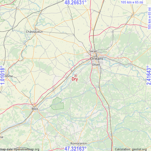
Dry GPS coordinates[2]
47° 47' 46.032" North, 1° 42' 47.88" East
| Map corner | latitude | longitude |
|---|---|---|
| Upper-left | 48.26631°, | 1.01018° |
| Center: | 47.79612°, | 1.7133° |
| Lower-right: | 47.32163°, | 2.41643° |
| Map W x H: | 105×105 km | = 65.2×65.2mi |
| max Lat: | 51.07786° ⇑44.3% North |
| Dry: | 47.79612° |
| min Lat: | ⇓55.7% South 41.3874° |
| min Long | Dry | max Long |
| -5.08615° | 1.7133° | 9.52242° |
| W 39.7%⇐ | ⇒60.3% E |
Elevation
Elevation of Dry is 91 m = 299 ft, and this is 102.7 m = 337 ft below average elevation for this country.
| Max E: |
2333 m = 7654 ft | 64.4% |
| Avg. | 193.7 m = 635 ft | |
| Dry | 91 m = 299 ft | |
Min E: |
-1 m = -3 ft | 35.6% |
See also: France elevation on elevation.city.
Geographical zone
Dry is located in North temperate zone (between Tropic of Cancer and the Arctic Circle). Distance of this North polar circle is 2086.7 km =1296.6 mi to North.| Distance of | km | miles | from Dry |
|---|---|---|---|
| North Pole | 4692.6 | 2915.8 | to North |
| Arctic Circle | 2086.7 | 1296.6 | to North |
| Tropic Cancer | 2708.5 | 1683 | to South |
| Equator | 5314.4 | 3302.2 | to South |


Nearby cities:
15 places around Dry: (largest is in red/bold)
• Baule
3.5 km =2.2 mi,  298°
298°
• Beaugency
6.7 km =4.2 mi,  254°
254°
• Chaingy
10.6 km =6.6 mi,  23°
23°
• Cléry-Saint-André
4 km =2.5 mi,  44°
44°
• Huisseau-sur-Mauves
10.8 km =6.7 mi,  355°
355°
• Jouy-le-Potier
9.2 km =5.7 mi,  127°
127°
• Lailly-en-Val
3.6 km =2.2 mi,  214°
214°
• Le Bardon
7.1 km =4.4 mi,  320°
320°
• Mareau-aux-Prés
9.4 km =5.8 mi,  33°
33°
• Messas
5.9 km =3.7 mi,  282°
282°
• Meung-sur-Loire
4.1 km =2.5 mi,  341°
341°
• Mézières-lez-Cléry
7.1 km =4.4 mi,  71°
71°
• Saint-Ay
7.5 km =4.7 mi, 22°
• Tavers
8.6 km =5.3 mi,  241°
241°
• Villorceau
8.7 km =5.4 mi,  273°
273°
Sources, notices
• [Note1] Compared only with cities in France existing in our database
• [Src1] Map data: © OpenStreetMap contributors (CC-BY-SA)
• [Src2] Other city data from geonames.org with taken over terms of usage.
• [Src3] Geographical zone / Annual Mean Temperature by Robert A. Rohde @ Wikipedia
