Coise geodata
Coise (Auvergne-Rhône-Alpes) is a populated place; located in France in Europe/Paris (GMT+2) time zone. With population of 1,018 people, there are 8707 cities with bigger population in this country. Compared to other cities in France, 73.8% of cities are located further ↑North; 88.7% of cities are located further ←West and 84.4% of cities have lower elevation than Coise. Note1
Administrative division(s):
- Level 1: Auvergne-Rhône-Alpes
- Level 2: Savoie
- Level 3: Arrondissement de Chambéry
- Level 4: Coise-Saint-Jean-Pied-Gauthier


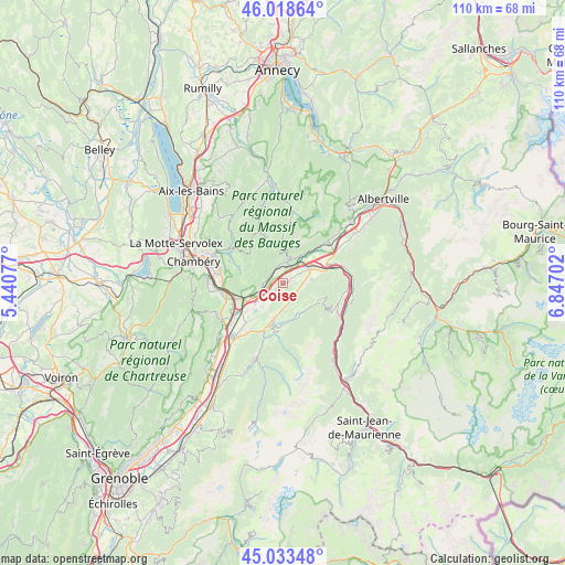
Coise GPS coordinates[2]
45° 31' 41.592" North, 6° 8' 38.004" East
| Map corner | latitude | longitude |
|---|---|---|
| Upper-left | 46.01864°, | 5.44077° |
| Center: | 45.52822°, | 6.14389° |
| Lower-right: | 45.03348°, | 6.84702° |
| Map W x H: | 109.5×109.5 km | = 68×68mi |
| max Lat: | 51.07786° ⇑73.8% North |
| Coise: | 45.52822° |
| min Lat: | ⇓26.2% South 41.3874° |
| min Long | Coise | max Long |
| -5.08615° | 6.14389° | 9.52242° |
| W 88.7%⇐ | ⇒11.3% E |
Elevation
Elevation of Coise is 340 m = 1115 ft, and this is 146.3 m = 480 ft above average elevation for this country.
| Max E: |
2333 m = 7654 ft | 15.6% |
| Coise | 340 m 1115 ft | |
| Avg. | 193.7 m = 635 ft | |
Min E: |
-1 m = -3 ft | 84.4% |
See also: France elevation on elevation.city.
Geographical zone
Coise is located in North temperate zone (between Tropic of Cancer and the Arctic Circle). Distance of this North polar circle is 2338.9 km =1453.3 mi to North.| Distance of | km | miles | from Coise |
|---|---|---|---|
| North Pole | 4944.8 | 3072.6 | to North |
| Arctic Circle | 2338.9 | 1453.3 | to North |
| Tropic Cancer | 2456.3 | 1526.3 | to South |
| Equator | 5062.3 | 3145.6 | to South |


Nearby cities:
15 places around Coise: (largest is in red/bold)
• Aiton
9.7 km =6 mi,  67°
67°
• Arbin
6 km =3.7 mi,  252°
252°
• Arvillard
9.7 km =6 mi,  191°
191°
• Chamoux-sur-Gelon
5.5 km =3.4 mi,  83°
83°
• Chignin
10.3 km =6.4 mi,  267°
267°
• Châteauneuf
3.2 km =2 mi,  44°
44°
• Cruet
4 km =2.5 mi, 271°
• Curienne
11.4 km =7.1 mi,  291°
291°
• Francin
9.2 km =5.7 mi, 249°
• La Rochette
8.2 km =5.1 mi,  196°
196°
• Les Marches
11.3 km =7 mi, 254°
• Les Mollettes
9.8 km =6.1 mi,  222°
222°
• Montmélian
7.3 km =4.5 mi, 249°
• Saint-Jean-de-la-Porte
3.3 km =2.1 mi,  340°
340°
• Sainte-Hélène-du-Lac
7.9 km =4.9 mi,  230°
230°
Sources, notices
• [Note1] Compared only with cities in France existing in our database
• [Src1] Map data: © OpenStreetMap contributors (CC-BY-SA)
• [Src2] Other city data from geonames.org with taken over terms of usage.
• [Src3] Geographical zone / Annual Mean Temperature by Robert A. Rohde @ Wikipedia
