Saint-Jean-de-la-Porte geodata
Saint-Jean-de-la-Porte (Auvergne-Rhône-Alpes) is a populated place; located in France in Europe/Paris (GMT+2) time zone. With population of 937 people, there are 9325 cities with bigger population in this country. Compared to other cities in France, 73.3% of cities are located further ↑North; 88.6% of cities are located further ←West and 78.8% of cities have lower elevation than Saint-Jean-de-la-Porte. Note1
Administrative division(s):
- Level 1: Auvergne-Rhône-Alpes
- Level 2: Savoie
- Level 3: Arrondissement de Chambéry
- Level 4: Saint-Jean-de-la-Porte
Current local time in Saint-Jean-de-la-Porte:
03:36 PM, SaturdayDifference from your time zone: hours


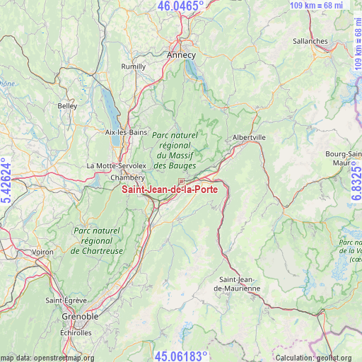
Saint-Jean-de-la-Porte GPS coordinates[2]
45° 33' 22.752" North, 6° 7' 45.732" East
| Map corner | latitude | longitude |
|---|---|---|
| Upper-left | 46.0465°, | 5.42624° |
| Center: | 45.55632°, | 6.12937° |
| Lower-right: | 45.06183°, | 6.8325° |
| Map W x H: | 109.5×109.5 km | = 68×68mi |
| max Lat: | 51.07786° ⇑73.3% North |
| Saint-Jean-de-la-Porte: | 45.55632° |
| min Lat: | ⇓26.7% South 41.3874° |
| min Long | Saint-Jean-de-l | max Long |
| -5.08615° | 6.12937° | 9.52242° |
| W 88.6%⇐ | ⇒11.4% E |
Elevation
Elevation of Saint-Jean-de-la-Porte is 279 m = 915 ft, and this is 85.3 m = 280 ft above average elevation for this country.
| Max E: |
2333 m = 7654 ft | 21.2% |
| Saint-Jean-de-la-Porte | 279 m 915 ft | |
| Avg. | 193.7 m = 635 ft | |
Min E: |
-1 m = -3 ft | 78.8% |
See also: France elevation on elevation.city.
Geographical zone
Saint-Jean-de-la-Porte is located in North temperate zone (between Tropic of Cancer and the Arctic Circle). Distance of this North polar circle is 2335.8 km =1451.4 mi to North.| Distance of | km | miles | from Saint-Jean-de-la-Porte |
|---|---|---|---|
| North Pole | 4941.7 | 3070.6 | to North |
| Arctic Circle | 2335.8 | 1451.4 | to North |
| Tropic Cancer | 2459.5 | 1528.3 | to South |
| Equator | 5065.4 | 3147.5 | to South |


Nearby cities:
15 places around Saint-Jean-de-la-Porte: (largest is in red/bold)
• Aiton
10.1 km =6.3 mi,  86°
86°
• Arbin
6.7 km =4.2 mi,  222°
222°
• Chamoux-sur-Gelon
7 km =4.3 mi,  110°
110°
• Chignin
9.8 km =6.1 mi,  248°
248°
• Châteauneuf
3.4 km =2.1 mi,  104°
104°
• Coise
3.3 km =2.1 mi,  160°
160°
• Cruet
4.2 km =2.6 mi, 223°
• Curienne
9.5 km =5.9 mi,  276°
276°
• Francin
9.8 km =6.1 mi,  229°
229°
• Grésy-sur-Isère
10.8 km =6.7 mi,  63°
63°
• La Rochette
11 km =6.8 mi,  186°
186°
• Les Marches
11.6 km =7.2 mi,  237°
237°
• Montmélian
8.1 km =5 mi, 224°
• Saint-Jeoire-Prieuré
11.3 km =7 mi, 254°
• Sainte-Hélène-du-Lac
9.6 km =6 mi,  211°
211°
Sources, notices
• [Note1] Compared only with cities in France existing in our database
• [Src1] Map data: © OpenStreetMap contributors (CC-BY-SA)
• [Src2] Other city data from geonames.org with taken over terms of usage.
• [Src3] Geographical zone / Annual Mean Temperature by Robert A. Rohde @ Wikipedia
