Anzin-Saint-Aubin geodata
Anzin-Saint-Aubin (Hauts-de-France) is a populated place; located in France in Europe/Paris (GMT+2) time zone. With population of 2,586 people, there are 3773 cities with bigger population in this country. Compared to other cities in France, 95.7% of cities are located further ↓South; 54.2% of cities are located further ←West and 70.5% of cities have higher elevation than Anzin-Saint-Aubin. Note1
Administrative division(s):
- Level 1: Hauts-de-France
- Level 2: Pas-de-Calais
- Level 3: Arras
- Level 4: Anzin-Saint-Aubin


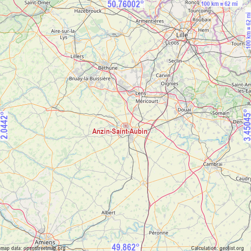
Anzin-Saint-Aubin GPS coordinates[2]
50° 18' 47.268" North, 2° 44' 50.352" East
| Map corner | latitude | longitude |
|---|---|---|
| Upper-left | 50.76002°, | 2.0442° |
| Center: | 50.31313°, | 2.74732° |
| Lower-right: | 49.862°, | 3.45045° |
| Map W x H: | 99.9×99.8 km | = 62.1×62mi |
| max Lat: | 51.07786° ⇑4.3% North |
| Anzin-Saint-Aubin: | 50.31313° |
| min Lat: | ⇓95.7% South 41.3874° |
| min Long | Anzin-Saint-Aub | max Long |
| -5.08615° | 2.74732° | 9.52242° |
| W 54.2%⇐ | ⇒45.8% E |
Elevation
Elevation of Anzin-Saint-Aubin is 77 m = 253 ft, and this is 116.7 m = 383 ft below average elevation for this country.
| Max E: |
2333 m = 7654 ft | 70.5% |
| Avg. | 193.7 m = 635 ft | |
| Anzin-Saint-Aubin | 77 m = 253 ft | |
Min E: |
-1 m = -3 ft | 29.5% |
See also: France elevation on elevation.city.
Geographical zone
Anzin-Saint-Aubin is located in North temperate zone (between Tropic of Cancer and the Arctic Circle). Distance of this North polar circle is 1806.9 km =1122.8 mi to North.| Distance of | km | miles | from Anzin-Saint-Aubin |
|---|---|---|---|
| North Pole | 4412.8 | 2742 | to North |
| Arctic Circle | 1806.9 | 1122.8 | to North |
| Tropic Cancer | 2988.4 | 1856.9 | to South |
| Equator | 5594.3 | 3476.1 | to South |


Nearby cities:
15 places around Anzin-Saint-Aubin: (largest is in red/bold)
• Achicourt
4.4 km =2.7 mi,  170°
170°
• Agny
6.1 km =3.8 mi, 171°
• Arras
3.3 km =2.1 mi,  132°
132°
• Beaurains
6.2 km =3.9 mi,  147°
147°
• Dainville
3.9 km =2.4 mi,  202°
202°
• Duisans
4.4 km =2.7 mi,  260°
260°
• Marœuil
3.3 km =2.1 mi,  294°
294°
• Mont-Saint-Éloi
5.7 km =3.5 mi,  317°
317°
• Neuville-Saint-Vaast
5.1 km =3.2 mi,  12°
12°
• Roclincourt
3.2 km =2 mi,  62°
62°
• Saint-Laurent-Blangy
4.7 km =2.9 mi,  116°
116°
• Saint-Nicolas
2.5 km =1.6 mi,  113°
113°
• Sainte-Catherine
1.3 km =0.8 mi, 117°
• Thélus
6 km =3.7 mi,  39°
39°
• Tilloy-lès-Mofflaines
6.4 km =4 mi, 131°
Sources, notices
• [Note1] Compared only with cities in France existing in our database
• [Src1] Map data: © OpenStreetMap contributors (CC-BY-SA)
• [Src2] Other city data from geonames.org with taken over terms of usage.
• [Src3] Geographical zone / Annual Mean Temperature by Robert A. Rohde @ Wikipedia
