Thélus geodata
Thélus (Hauts-de-France) is a populated place; located in France in Europe/Paris (GMT+2) time zone. With population of 1,047 people, there are 8486 cities with bigger population in this country. Compared to other cities in France, 96% of cities are located further ↓South; 54.9% of cities are located further ←West and 52.6% of cities have higher elevation than Thélus. Note1
Administrative division(s):
- Level 1: Hauts-de-France
- Level 2: Pas-de-Calais
- Level 3: Arras
- Level 4: Thélus


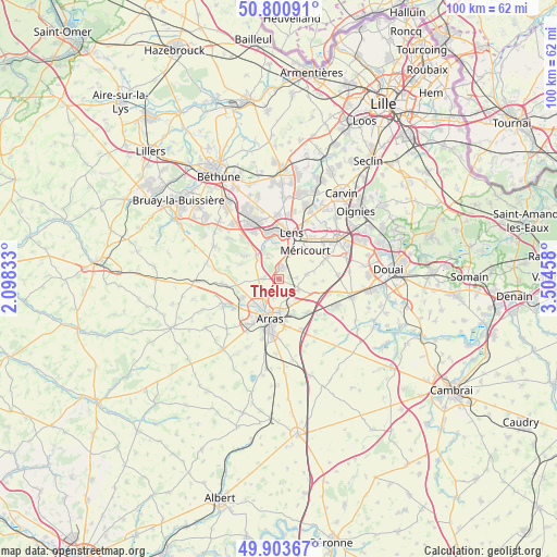
Thélus GPS coordinates[2]
50° 21' 15.876" North, 2° 48' 5.256" East
| Map corner | latitude | longitude |
|---|---|---|
| Upper-left | 50.80091°, | 2.09833° |
| Center: | 50.35441°, | 2.80146° |
| Lower-right: | 49.90367°, | 3.50458° |
| Map W x H: | 99.8×99.8 km | = 62×62mi |
| max Lat: | 51.07786° ⇑4% North |
| Thélus: | 50.35441° |
| min Lat: | ⇓96% South 41.3874° |
| min Long | Thélus | max Long |
| -5.08615° | 2.80146° | 9.52242° |
| W 54.9%⇐ | ⇒45.1% E |
Elevation
Elevation of Thélus is 123 m = 404 ft, and this is 70.7 m = 232 ft below average elevation for this country.
| Max E: |
2333 m = 7654 ft | 52.6% |
| Avg. | 193.7 m = 635 ft | |
| Thélus | 123 m = 404 ft | |
Min E: |
-1 m = -3 ft | 47.4% |
See also: France elevation on elevation.city.
Geographical zone
Thélus is located in North temperate zone (between Tropic of Cancer and the Arctic Circle). Distance of this North polar circle is 1802.3 km =1119.9 mi to North.| Distance of | km | miles | from Thélus |
|---|---|---|---|
| North Pole | 4408.2 | 2739.1 | to North |
| Arctic Circle | 1802.3 | 1119.9 | to North |
| Tropic Cancer | 2993 | 1859.8 | to South |
| Equator | 5598.9 | 3479 | to South |


Nearby cities:
15 places around Thélus: (largest is in red/bold)
• Angres
6.4 km =4 mi,  333°
333°
• Anzin-Saint-Aubin
6 km =3.7 mi,  219°
219°
• Arleux-en-Gohelle
5.1 km =3.2 mi,  78°
78°
• Athies
6.4 km =4 mi,  156°
156°
• Avion
6.6 km =4.1 mi,  18°
18°
• Bailleul-Sir-Berthoult
4 km =2.5 mi,  117°
117°
• Farbus
1.7 km =1.1 mi, 82°
• Givenchy-en-Gohelle
4.5 km =2.8 mi, 333°
• Neuville-Saint-Vaast
2.8 km =1.7 mi,  277°
277°
• Roclincourt
3.3 km =2.1 mi,  198°
198°
• Saint-Nicolas
5.8 km =3.6 mi, 195°
• Sainte-Catherine
5.8 km =3.6 mi,  207°
207°
• Souchez
6.1 km =3.8 mi,  314°
314°
• Vimy
2.1 km =1.3 mi, 17°
• Willerval
3.1 km =1.9 mi,  85°
85°
Sources, notices
• [Note1] Compared only with cities in France existing in our database
• [Src1] Map data: © OpenStreetMap contributors (CC-BY-SA)
• [Src2] Other city data from geonames.org with taken over terms of usage.
• [Src3] Geographical zone / Annual Mean Temperature by Robert A. Rohde @ Wikipedia
