Neuville-Saint-Vaast geodata
Neuville-Saint-Vaast (Hauts-de-France) is a populated place; located in France in Europe/Paris (GMT+2) time zone. With population of 1,444 people, there are 6409 cities with bigger population in this country. Compared to other cities in France, 96.1% of cities are located further ↓South; 54.4% of cities are located further ←West and 57.6% of cities have higher elevation than Neuville-Saint-Vaast. Note1
Administrative division(s):
- Level 1: Hauts-de-France
- Level 2: Pas-de-Calais
- Level 3: Arras
- Level 4: Neuville-Saint-Vaast
Current local time in Neuville-Saint-Vaast:
01:40 PM, WednesdayDifference from your time zone: hours


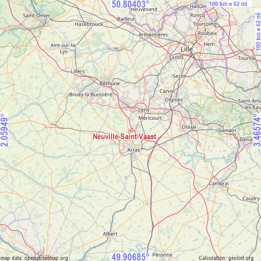
Neuville-Saint-Vaast GPS coordinates[2]
50° 21' 27.216" North, 2° 45' 45.396" East
| Map corner | latitude | longitude |
|---|---|---|
| Upper-left | 50.80403°, | 2.05949° |
| Center: | 50.35756°, | 2.76261° |
| Lower-right: | 49.90685°, | 3.46574° |
| Map W x H: | 99.8×99.8 km | = 62×62mi |
| max Lat: | 51.07786° ⇑3.9% North |
| Neuville-Saint-Vaast: | 50.35756° |
| min Lat: | ⇓96.1% South 41.3874° |
| min Long | Neuville-Saint- | max Long |
| -5.08615° | 2.76261° | 9.52242° |
| W 54.4%⇐ | ⇒45.6% E |
Elevation
Elevation of Neuville-Saint-Vaast is 109 m = 358 ft, and this is 84.7 m = 278 ft below average elevation for this country.
| Max E: |
2333 m = 7654 ft | 57.6% |
| Avg. | 193.7 m = 635 ft | |
| Neuville-Saint-Vaast | 109 m = 358 ft | |
Min E: |
-1 m = -3 ft | 42.4% |
See also: France elevation on elevation.city.
Geographical zone
Neuville-Saint-Vaast is located in North temperate zone (between Tropic of Cancer and the Arctic Circle). Distance of this North polar circle is 1801.9 km =1119.6 mi to North.| Distance of | km | miles | from Neuville-Saint-Vaast |
|---|---|---|---|
| North Pole | 4407.8 | 2738.9 | to North |
| Arctic Circle | 1801.9 | 1119.6 | to North |
| Tropic Cancer | 2993.3 | 1859.9 | to South |
| Equator | 5599.2 | 3479.2 | to South |


Nearby cities:
15 places around Neuville-Saint-Vaast: (largest is in red/bold)
• Ablain-Saint-Nazaire
5.5 km =3.4 mi,  316°
316°
• Angres
5.4 km =3.4 mi,  358°
358°
• Anzin-Saint-Aubin
5.1 km =3.2 mi,  192°
192°
• Carency
4.8 km =3 mi,  299°
299°
• Farbus
4.4 km =2.7 mi,  91°
91°
• Givenchy-en-Gohelle
3.8 km =2.4 mi,  11°
11°
• Marœuil
5.4 km =3.4 mi,  228°
228°
• Mont-Saint-Éloi
5 km =3.1 mi,  261°
261°
• Roclincourt
3.9 km =2.4 mi,  153°
153°
• Saint-Nicolas
6.1 km =3.8 mi,  168°
168°
• Sainte-Catherine
5.6 km =3.5 mi,  178°
178°
• Souchez
4.2 km =2.6 mi,  337°
337°
• Thélus
2.8 km =1.7 mi,  97°
97°
• Vimy
3.8 km =2.4 mi,  63°
63°
• Willerval
5.8 km =3.6 mi, 91°
Sources, notices
• [Note1] Compared only with cities in France existing in our database
• [Src1] Map data: © OpenStreetMap contributors (CC-BY-SA)
• [Src2] Other city data from geonames.org with taken over terms of usage.
• [Src3] Geographical zone / Annual Mean Temperature by Robert A. Rohde @ Wikipedia
