Angliers geodata
Angliers (Nouvelle-Aquitaine) is a populated place; located in France in Europe/Paris (GMT+2) time zone. With population of 662 people, there are 12351 cities with bigger population in this country. Compared to other cities in France, 55.9% of cities are located further ↑North; 77.1% of cities are located further →East and 76.6% of cities have higher elevation than Angliers. Note1
Administrative division(s):
- Level 1: Nouvelle-Aquitaine
- Level 2: Vienne
- Level 3: Arrondissement de Châtellerault
- Level 4: Angliers


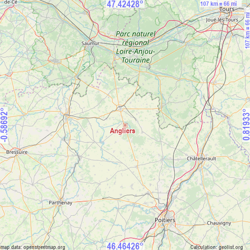
Angliers GPS coordinates[2]
46° 56' 47.112" North, 0° 6' 58.356" East
| Map corner | latitude | longitude |
|---|---|---|
| Upper-left | 47.42428°, | -0.58692° |
| Center: | 46.94642°, | 0.11621° |
| Lower-right: | 46.46426°, | 0.81933° |
| Map W x H: | 106.7×106.7 km | = 66.3×66.3mi |
| max Lat: | 51.07786° ⇑55.9% North |
| Angliers: | 46.94642° |
| min Lat: | ⇓44.1% South 41.3874° |
| min Long | Angliers | max Long |
| -5.08615° | 0.11621° | 9.52242° |
| W 22.9%⇐ | ⇒77.1% E |
Elevation
Elevation of Angliers is 63 m = 207 ft, and this is 130.7 m = 429 ft below average elevation for this country.
| Max E: |
2333 m = 7654 ft | 76.6% |
| Avg. | 193.7 m = 635 ft | |
| Angliers | 63 m = 207 ft | |
Min E: |
-1 m = -3 ft | 23.4% |
See also: France elevation on elevation.city.
Geographical zone
Angliers is located in North temperate zone (between Tropic of Cancer and the Arctic Circle). Distance of this North polar circle is 2181.2 km =1355.3 mi to North.| Distance of | km | miles | from Angliers |
|---|---|---|---|
| North Pole | 4787.1 | 2974.6 | to North |
| Arctic Circle | 2181.2 | 1355.3 | to North |
| Tropic Cancer | 2614 | 1624.3 | to South |
| Equator | 5220 | 3243.6 | to South |


Nearby cities:
15 places around Angliers: (largest is in red/bold)
• Beuxes
17.1 km =10.6 mi,  16°
16°
• Ceaux-en-Loudun
12.8 km =8 mi,  46°
46°
• Chalais
3.5 km =2.2 mi,  322°
322°
• Chouppes
15.4 km =9.6 mi,  166°
166°
• Doussay
16.6 km =10.3 mi,  133°
133°
• Les Trois-Moutiers
14.9 km =9.3 mi,  330°
330°
• Loudun
7.3 km =4.5 mi,  339°
339°
• Moncontour
12.5 km =7.8 mi,  234°
234°
• Monts-sur-Guesnes
7.9 km =4.9 mi,  112°
112°
• Mouterre-Silly
6.3 km =3.9 mi,  300°
300°
• Oiron
15 km =9.3 mi,  272°
272°
• Pouant
13.5 km =8.4 mi,  60°
60°
• Saint-Jean-de-Sauves
11.9 km =7.4 mi,  188°
188°
• Saint-Jouin-de-Marnes
14.9 km =9.3 mi,  240°
240°
• Sammarçolles
9.8 km =6.1 mi,  13°
13°
Sources, notices
• [Note1] Compared only with cities in France existing in our database
• [Src1] Map data: © OpenStreetMap contributors (CC-BY-SA)
• [Src2] Other city data from geonames.org with taken over terms of usage.
• [Src3] Geographical zone / Annual Mean Temperature by Robert A. Rohde @ Wikipedia
