Les Trois-Moutiers geodata
Les Trois-Moutiers (Nouvelle-Aquitaine) is a populated place; located in France in Europe/Paris (GMT+2) time zone. With population of 995 people, there are 8868 cities with bigger population in this country. Compared to other cities in France, 54.6% of cities are located further ↑North; 78% of cities are located further →East and 80.2% of cities have higher elevation than Les Trois-Moutiers. Note1
Administrative division(s):
- Level 1: Nouvelle-Aquitaine
- Level 2: Vienne
- Level 3: Arrondissement de Châtellerault
- Level 4: Les Trois-Moutiers


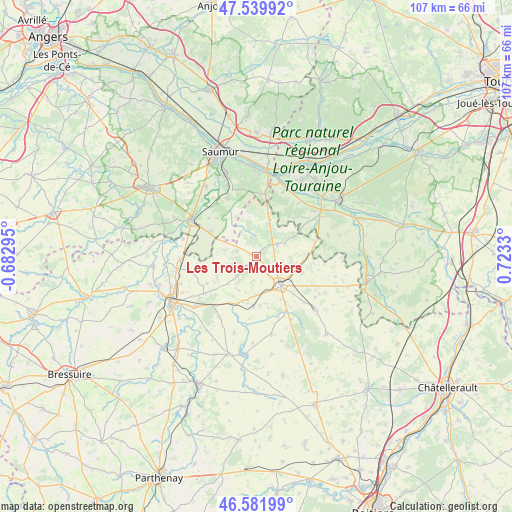
Les Trois-Moutiers GPS coordinates[2]
47° 3' 47.196" North, 0° 1' 12.648" East
| Map corner | latitude | longitude |
|---|---|---|
| Upper-left | 47.53992°, | -0.68295° |
| Center: | 47.06311°, | 0.02018° |
| Lower-right: | 46.58199°, | 0.7233° |
| Map W x H: | 106.5×106.5 km | = 66.2×66.2mi |
| max Lat: | 51.07786° ⇑54.6% North |
| Les Trois-Moutiers: | 47.06311° |
| min Lat: | ⇓45.4% South 41.3874° |
| min Long | Les Trois-Mouti | max Long |
| -5.08615° | 0.02018° | 9.52242° |
| W 22%⇐ | ⇒78% E |
Elevation
Elevation of Les Trois-Moutiers is 54 m = 177 ft, and this is 139.7 m = 458 ft below average elevation for this country.
| Max E: |
2333 m = 7654 ft | 80.2% |
| Avg. | 193.7 m = 635 ft | |
| Les Trois-Moutiers | 54 m = 177 ft | |
Min E: |
-1 m = -3 ft | 19.8% |
See also: France elevation on elevation.city.
Geographical zone
Les Trois-Moutiers is located in North temperate zone (between Tropic of Cancer and the Arctic Circle). Distance of this North polar circle is 2168.2 km =1347.3 mi to North.| Distance of | km | miles | from Les Trois-Moutiers |
|---|---|---|---|
| North Pole | 4774.1 | 2966.5 | to North |
| Arctic Circle | 2168.2 | 1347.3 | to North |
| Tropic Cancer | 2627 | 1632.3 | to South |
| Equator | 5232.9 | 3251.6 | to South |


Nearby cities:
15 places around Les Trois-Moutiers: (largest is in red/bold)
• Angliers
14.9 km =9.3 mi,  150°
150°
• Beuxes
12.5 km =7.8 mi,  74°
74°
• Brion-près-Thouet
15.7 km =9.8 mi,  265°
265°
• Brézé
13.7 km =8.5 mi,  333°
333°
• Chalais
11.4 km =7.1 mi, 153°
• Fontevraud-l'Abbaye
13.6 km =8.5 mi,  9°
9°
• Loudun
7.8 km =4.8 mi,  142°
142°
• Montreuil-Bellay
15.1 km =9.4 mi,  300°
300°
• Mouterre-Silly
9.9 km =6.2 mi,  169°
169°
• Oiron
14.6 km =9.1 mi,  211°
211°
• Roiffé
7.2 km =4.5 mi,  19°
19°
• Saint-Cyr-en-Bourg
15.9 km =9.9 mi,  337°
337°
• Saint-Léger-de-Montbrun
13.6 km =8.5 mi,  238°
238°
• Sammarçolles
10.1 km =6.3 mi,  109°
109°
• Épieds
10.2 km =6.3 mi, 330°
Sources, notices
• [Note1] Compared only with cities in France existing in our database
• [Src1] Map data: © OpenStreetMap contributors (CC-BY-SA)
• [Src2] Other city data from geonames.org with taken over terms of usage.
• [Src3] Geographical zone / Annual Mean Temperature by Robert A. Rohde @ Wikipedia
