Allègre geodata
Allègre (Auvergne-Rhône-Alpes) is a populated place; located in France in Europe/Paris (GMT+2) time zone. With population of 1,070 people, there are 8333 cities with bigger population in this country. Compared to other cities in France, 77.5% of cities are located further ↑North; 65.8% of cities are located further ←West and 99.3% of cities have lower elevation than Allègre. Note1
Administrative division(s):
- Level 1: Auvergne-Rhône-Alpes
- Level 2: Haute-Loire
- Level 3: Arrondissement du Puy-en-Velay
- Level 4: Allègre


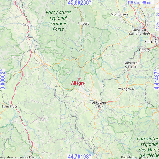
Allègre GPS coordinates[2]
45° 11' 58.524" North, 3° 42' 42.264" East
| Map corner | latitude | longitude |
|---|---|---|
| Upper-left | 45.69288°, | 3.00862° |
| Center: | 45.19959°, | 3.71174° |
| Lower-right: | 44.70198°, | 4.41487° |
| Map W x H: | 110.2×110.2 km | = 68.5×68.5mi |
| max Lat: | 51.07786° ⇑77.5% North |
| Allègre: | 45.19959° |
| min Lat: | ⇓22.5% South 41.3874° |
| min Long | Allègre | max Long |
| -5.08615° | 3.71174° | 9.52242° |
| W 65.8%⇐ | ⇒34.2% E |
Elevation
Elevation of Allègre is 1055 m = 3461 ft, and this is 861.3 m = 2826 ft above average elevation for this country.
| Max E: |
2333 m = 7654 ft | 0.7% |
| Allègre | 1055 m 3461 ft | |
| Avg. | 193.7 m = 635 ft | |
Min E: |
-1 m = -3 ft | 99.3% |
See also: France elevation on elevation.city.
Geographical zone
Allègre is located in North temperate zone (between Tropic of Cancer and the Arctic Circle). Distance of this North polar circle is 2375.5 km =1476.1 mi to North.| Distance of | km | miles | from Allègre |
|---|---|---|---|
| North Pole | 4981.3 | 3095.2 | to North |
| Arctic Circle | 2375.5 | 1476.1 | to North |
| Tropic Cancer | 2419.8 | 1503.6 | to South |
| Equator | 5025.7 | 3122.8 | to South |


Nearby cities:
15 places around Allègre: (largest is in red/bold)
• Bellevue-la-Montagne
8.8 km =5.5 mi,  74°
74°
• Cerzat
18.7 km =11.6 mi,  256°
256°
• Chaspuzac
14.9 km =9.3 mi,  168°
168°
• Chomelix
11.4 km =7.1 mi,  52°
52°
• Craponne-sur-Arzon
18.1 km =11.2 mi,  36°
36°
• Fontannes
12 km =7.5 mi,  19°
19°
• La Chaise-Dieu
13.6 km =8.5 mi,  355°
355°
• Langeac
20.3 km =12.6 mi,  237°
237°
• Lavoûte-sur-Loire
17.7 km =11 mi,  120°
120°
• Loudes
12.7 km =7.9 mi, 166°
• Paulhaguet
15.6 km =9.7 mi,  273°
273°
• Polignac
18.5 km =11.5 mi,  140°
140°
• Saint-Paulien
10.6 km =6.6 mi,  131°
131°
• Saint-Vincent
16.7 km =10.4 mi,  111°
111°
• Vorey
15.6 km =9.7 mi,  95°
95°
Sources, notices
• [Note1] Compared only with cities in France existing in our database
• [Src1] Map data: © OpenStreetMap contributors (CC-BY-SA)
• [Src2] Other city data from geonames.org with taken over terms of usage.
• [Src3] Geographical zone / Annual Mean Temperature by Robert A. Rohde @ Wikipedia
