Langeac geodata
Langeac (Auvergne-Rhône-Alpes) is a populated place; located in France in Europe/Paris (GMT+2) time zone. With population of 3,997 people, there are 2458 cities with bigger population in this country. Compared to other cities in France, 78.5% of cities are located further ↑North; 64.2% of cities are located further ←West and 92.2% of cities have lower elevation than Langeac. Note1
Administrative division(s):
- Level 1: Auvergne-Rhône-Alpes
- Level 2: Haute-Loire
- Level 3: Arrondissement de Brioude
- Level 4: Langeac


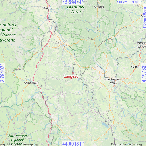
Langeac GPS coordinates[2]
45° 6' 1.008" North, 3° 29' 39.12" East
| Map corner | latitude | longitude |
|---|---|---|
| Upper-left | 45.59444°, | 2.79107° |
| Center: | 45.10028°, | 3.4942° |
| Lower-right: | 44.60181°, | 4.19732° |
| Map W x H: | 110.4×110.4 km | = 68.6×68.6mi |
| max Lat: | 51.07786° ⇑78.5% North |
| Langeac: | 45.10028° |
| min Lat: | ⇓21.5% South 41.3874° |
| min Long | Langeac | max Long |
| -5.08615° | 3.4942° | 9.52242° |
| W 64.2%⇐ | ⇒35.8% E |
Elevation
Elevation of Langeac is 480 m = 1575 ft, and this is 286.3 m = 939 ft above average elevation for this country.
| Max E: |
2333 m = 7654 ft | 7.8% |
| Langeac | 480 m 1575 ft | |
| Avg. | 193.7 m = 635 ft | |
Min E: |
-1 m = -3 ft | 92.2% |
See also: France elevation on elevation.city.
Geographical zone
Langeac is located in North temperate zone (between Tropic of Cancer and the Arctic Circle). Distance of this North polar circle is 2386.5 km =1482.9 mi to North.| Distance of | km | miles | from Langeac |
|---|---|---|---|
| North Pole | 4992.4 | 3102.1 | to North |
| Arctic Circle | 2386.5 | 1482.9 | to North |
| Tropic Cancer | 2408.8 | 1496.8 | to South |
| Equator | 5014.7 | 3116 | to South |


Nearby cities:
15 places around Langeac: (largest is in red/bold)
• Allègre
20.3 km =12.6 mi,  57°
57°
• Bains
24.3 km =15.1 mi,  114°
114°
• Brioude
23.2 km =14.4 mi,  338°
338°
• Cerzat
6.9 km =4.3 mi,  350°
350°
• Chaspuzac
20.3 km =12.6 mi,  100°
100°
• Cohade
28 km =17.4 mi, 340°
• Lamothe
24.3 km =15.1 mi, 346°
• Loudes
20 km =12.4 mi,  93°
93°
• Massiac
28.7 km =17.8 mi,  305°
305°
• Paulhac
25.1 km =15.6 mi,  332°
332°
• Paulhaguet
12.1 km =7.5 mi,  7°
7°
• Saint-Christophe-sur-Dolaison
28.1 km =17.5 mi, 114°
• Saint-Paulien
25.3 km =15.7 mi,  80°
80°
• Saugues
16.1 km =10 mi,  164°
164°
• Vieille-Brioude
19.6 km =12.2 mi, 339°
Sources, notices
• [Note1] Compared only with cities in France existing in our database
• [Src1] Map data: © OpenStreetMap contributors (CC-BY-SA)
• [Src2] Other city data from geonames.org with taken over terms of usage.
• [Src3] Geographical zone / Annual Mean Temperature by Robert A. Rohde @ Wikipedia
