Allauch geodata
Allauch (Provence-Alpes-Côte d'Azur) is a populated place; located in France in Europe/Paris (GMT+2) time zone. With population of 21,406 people, there are 422 cities with bigger population in this country. Compared to other cities in France, 95% of cities are located further ↑North; 82.7% of cities are located further ←West and 70.1% of cities have lower elevation than Allauch. Note1
Administrative division(s):
- Level 1: Provence-Alpes-Côte d'Azur
- Level 2: Département des Bouches-du-Rhône
- Level 3: Arrondissement de Marseille
- Level 4: Allauch


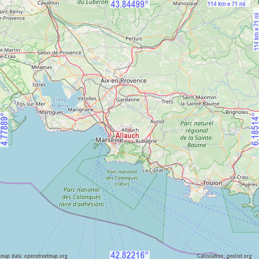
Allauch GPS coordinates[2]
43° 20' 8.628" North, 5° 28' 55.236" East
| Map corner | latitude | longitude |
|---|---|---|
| Upper-left | 43.84499°, | 4.77889° |
| Center: | 43.33573°, | 5.48201° |
| Lower-right: | 42.82216°, | 6.18514° |
| Map W x H: | 113.7×113.7 km | = 70.6×70.6mi |
| max Lat: | 51.07786° ⇑95% North |
| Allauch: | 43.33573° |
| min Lat: | ⇓5% South 41.3874° |
| min Long | Allauch | max Long |
| -5.08615° | 5.48201° | 9.52242° |
| W 82.7%⇐ | ⇒17.3% E |
Elevation
Elevation of Allauch is 220 m = 722 ft, and this is 26.3 m = 86 ft above average elevation for this country.
| Max E: |
2333 m = 7654 ft | 29.9% |
| Allauch | 220 m 722 ft | |
| Avg. | 193.7 m = 635 ft | |
Min E: |
-1 m = -3 ft | 70.1% |
See also: France elevation on elevation.city.
Geographical zone
Allauch is located in North temperate zone (between Tropic of Cancer and the Arctic Circle). Distance of this Northern Tropic circle is 2212.6 km =1374.8 mi to South.| Distance of | km | miles | from Allauch |
|---|---|---|---|
| North Pole | 5188.6 | 3224 | to North |
| Arctic Circle | 2582.7 | 1604.8 | to North |
| Tropic Cancer | 2212.6 | 1374.8 | to South |
| Equator | 4818.5 | 2994.1 | to South |


Nearby cities:
15 places around Allauch: (largest is in red/bold)
• La Croix-Rouge
2.3 km =1.4 mi,  263°
263°
• La Rose
4.4 km =2.7 mi, 260°
• La Treille
3.3 km =2.1 mi,  136°
136°
• La Valentine
4.2 km =2.6 mi,  177°
177°
• Les Accates
4.2 km =2.6 mi,  162°
162°
• Les Caillols
4.6 km =2.9 mi,  216°
216°
• Les Camoins
4.4 km =2.7 mi, 138°
• Les Médecins
3 km =1.9 mi,  313°
313°
• Les Olives
2.3 km =1.4 mi,  235°
235°
• Les Trois-Lucs
2.9 km =1.8 mi,  212°
212°
• Palama
4.5 km =2.8 mi,  317°
317°
• Plan-de-Cuques
2 km =1.2 mi, 311°
• Saint-Julien
3.6 km =2.2 mi,  226°
226°
• Saint-Mitre
4.9 km =3 mi,  283°
283°
• Éoures
5.1 km =3.2 mi, 140°
Sources, notices
• [Note1] Compared only with cities in France existing in our database
• [Src1] Map data: © OpenStreetMap contributors (CC-BY-SA)
• [Src2] Other city data from geonames.org with taken over terms of usage.
• [Src3] Geographical zone / Annual Mean Temperature by Robert A. Rohde @ Wikipedia
