La Croix-Rouge geodata
La Croix-Rouge (Provence-Alpes-Côte d'Azur) is a section of populated place; located in France in Europe/Paris (GMT+2) time zone. With population of 6,348 people, there are 1559 cities with bigger population in this country. Compared to other cities in France, 95.1% of cities are located further ↑North; 82.5% of cities are located further ←West and 55.6% of cities have higher elevation than La Croix-Rouge. Note1
Administrative division(s):
- Level 1: Provence-Alpes-Côte d'Azur
- Level 2: Département des Bouches-du-Rhône
- Level 3: Arrondissement de Marseille
- Level 4: Marseille


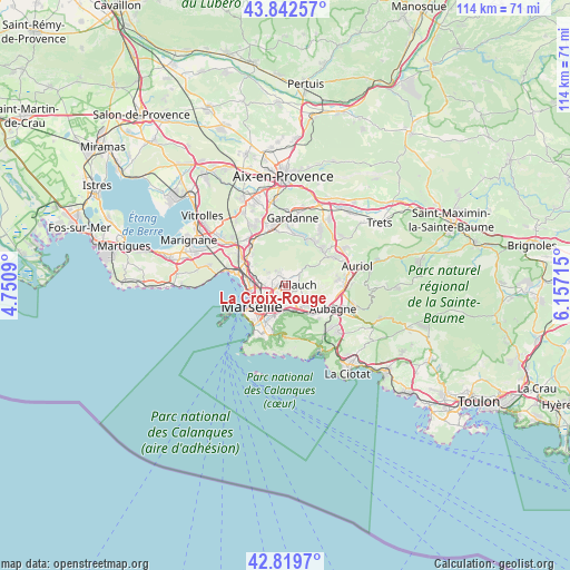
La Croix-Rouge GPS coordinates[2]
43° 19' 59.844" North, 5° 27' 14.508" East
| Map corner | latitude | longitude |
|---|---|---|
| Upper-left | 43.84257°, | 4.7509° |
| Center: | 43.33329°, | 5.45403° |
| Lower-right: | 42.8197°, | 6.15715° |
| Map W x H: | 113.7×113.7 km | = 70.6×70.6mi |
| max Lat: | 51.07786° ⇑95.1% North |
| La Croix-Rouge: | 43.33329° |
| min Lat: | ⇓4.9% South 41.3874° |
| min Long | La Croix-Rouge | max Long |
| -5.08615° | 5.45403° | 9.52242° |
| W 82.5%⇐ | ⇒17.5% E |
Elevation
Elevation of La Croix-Rouge is 115 m = 377 ft, and this is 78.7 m = 258 ft below average elevation for this country.
| Max E: |
2333 m = 7654 ft | 55.6% |
| Avg. | 193.7 m = 635 ft | |
| La Croix-Rouge | 115 m = 377 ft | |
Min E: |
-1 m = -3 ft | 44.4% |
See also: France elevation on elevation.city.
Geographical zone
La Croix-Rouge is located in North temperate zone (between Tropic of Cancer and the Arctic Circle). Distance of this Northern Tropic circle is 2212.3 km =1374.7 mi to South.| Distance of | km | miles | from La Croix-Rouge |
|---|---|---|---|
| North Pole | 5188.9 | 3224.2 | to North |
| Arctic Circle | 2583 | 1605 | to North |
| Tropic Cancer | 2212.3 | 1374.7 | to South |
| Equator | 4818.2 | 2993.9 | to South |


Nearby cities:
15 places around La Croix-Rouge: (largest is in red/bold)
• Allauch
2.3 km =1.4 mi,  83°
83°
• La Fourragère
3.8 km =2.4 mi,  209°
209°
• La Rose
2.1 km =1.3 mi,  256°
256°
• Les Caillols
3.5 km =2.2 mi,  187°
187°
• Les Médecins
2.3 km =1.4 mi,  1°
1°
• Les Olives
1.1 km =0.7 mi,  161°
161°
• Les Trois-Lucs
2.3 km =1.4 mi, 162°
• Malpassé
3.4 km =2.1 mi,  247°
247°
• Montolivet
3.1 km =1.9 mi,  233°
233°
• Mouret
3.7 km =2.3 mi,  328°
328°
• Palama
3.7 km =2.3 mi,  347°
347°
• Plan-de-Cuques
1.8 km =1.1 mi,  26°
26°
• Saint-Julien
2.3 km =1.4 mi, 189°
• Saint-Jérôme
3 km =1.9 mi,  271°
271°
• Saint-Mitre
2.9 km =1.8 mi,  299°
299°
Sources, notices
• [Note1] Compared only with cities in France existing in our database
• [Src1] Map data: © OpenStreetMap contributors (CC-BY-SA)
• [Src2] Other city data from geonames.org with taken over terms of usage.
• [Src3] Geographical zone / Annual Mean Temperature by Robert A. Rohde @ Wikipedia
