Plan-de-Cuques geodata
Plan-de-Cuques (Provence-Alpes-Côte d'Azur) is a populated place; located in France in Europe/Paris (GMT+2) time zone. With population of 11,125 people, there are 865 cities with bigger population in this country. Compared to other cities in France, 94.9% of cities are located further ↑North; 82.6% of cities are located further ←West and 50.3% of cities have lower elevation than Plan-de-Cuques. Note1
Administrative division(s):
- Level 1: Provence-Alpes-Côte d'Azur
- Level 2: Département des Bouches-du-Rhône
- Level 3: Arrondissement de Marseille
- Level 4: Plan-de-Cuques


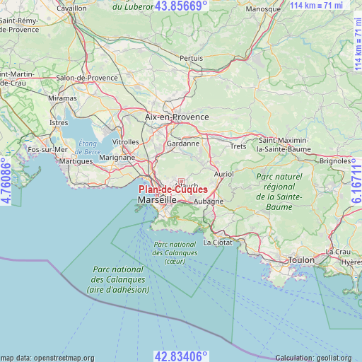
Plan-de-Cuques GPS coordinates[2]
43° 20' 51.108" North, 5° 27' 50.328" East
| Map corner | latitude | longitude |
|---|---|---|
| Upper-left | 43.85669°, | 4.76086° |
| Center: | 43.34753°, | 5.46398° |
| Lower-right: | 42.83406°, | 6.16711° |
| Map W x H: | 113.7×113.7 km | = 70.6×70.6mi |
| max Lat: | 51.07786° ⇑94.9% North |
| Plan-de-Cuques: | 43.34753° |
| min Lat: | ⇓5.1% South 41.3874° |
| min Long | Plan-de-Cuques | max Long |
| -5.08615° | 5.46398° | 9.52242° |
| W 82.6%⇐ | ⇒17.4% E |
Elevation
Elevation of Plan-de-Cuques is 133 m = 436 ft, and this is 60.7 m = 199 ft below average elevation for this country.
| Max E: |
2333 m = 7654 ft | 49.7% |
| Avg. | 193.7 m = 635 ft | |
| Plan-de-Cuques | 133 m = 436 ft | |
Min E: |
-1 m = -3 ft | 50.3% |
See also: France elevation on elevation.city.
Geographical zone
Plan-de-Cuques is located in North temperate zone (between Tropic of Cancer and the Arctic Circle). Distance of this Northern Tropic circle is 2213.9 km =1375.7 mi to South.| Distance of | km | miles | from Plan-de-Cuques |
|---|---|---|---|
| North Pole | 5187.3 | 3223.2 | to North |
| Arctic Circle | 2581.4 | 1604 | to North |
| Tropic Cancer | 2213.9 | 1375.7 | to South |
| Equator | 4819.8 | 2994.9 | to South |


Nearby cities:
15 places around Plan-de-Cuques: (largest is in red/bold)
• Allauch
2 km =1.2 mi,  131°
131°
• La Croix-Rouge
1.8 km =1.1 mi,  206°
206°
• La Rose
3.5 km =2.2 mi,  234°
234°
• La Treille
5.2 km =3.2 mi,  135°
135°
• Le Merlan
4.7 km =2.9 mi,  257°
257°
• Les Médecins
1 km =0.6 mi,  314°
314°
• Les Olives
2.7 km =1.7 mi,  189°
189°
• Les Trois-Lucs
3.8 km =2.4 mi,  181°
181°
• Malpassé
4.9 km =3 mi, 233°
• Montolivet
4.7 km =2.9 mi,  224°
224°
• Mouret
3.1 km =1.9 mi,  299°
299°
• Palama
2.6 km =1.6 mi,  321°
321°
• Saint-Julien
4 km =2.5 mi,  197°
197°
• Saint-Jérôme
4.1 km =2.5 mi,  248°
248°
• Saint-Mitre
3.3 km =2.1 mi,  267°
267°
Sources, notices
• [Note1] Compared only with cities in France existing in our database
• [Src1] Map data: © OpenStreetMap contributors (CC-BY-SA)
• [Src2] Other city data from geonames.org with taken over terms of usage.
• [Src3] Geographical zone / Annual Mean Temperature by Robert A. Rohde @ Wikipedia
