Montauban geodata
Montauban (Occitanie) is a seat of a second-order administrative division; located in France in Europe/Paris (GMT+2) time zone. With population of 52,434 people, there are 113 cities with bigger population in this country. Compared to other cities in France, 86.9% of cities are located further ↑North; 64.8% of cities are located further →East and 59.1% of cities have higher elevation than Montauban. Note1
Administrative division(s):
- Level 1: Occitanie
- Level 2: Département du Tarn-et-Garonne
- Level 3: Arrondissement de Montauban
- Level 4: Montauban


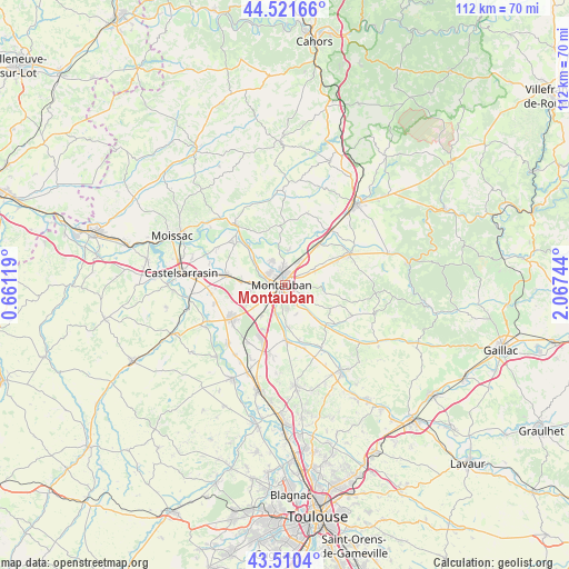
Montauban GPS coordinates[2]
44° 1' 5.484" North, 1° 21' 51.552" East
| Map corner | latitude | longitude |
|---|---|---|
| Upper-left | 44.52166°, | 0.66119° |
| Center: | 44.01819°, | 1.36432° |
| Lower-right: | 43.5104°, | 2.06744° |
| Map W x H: | 112.4×112.4 km | = 69.8×69.8mi |
| max Lat: | 51.07786° ⇑86.9% North |
| Montauban: | 44.01819° |
| min Lat: | ⇓13.1% South 41.3874° |
| min Long | Montauban | max Long |
| -5.08615° | 1.36432° | 9.52242° |
| W 35.2%⇐ | ⇒64.8% E |
Elevation
Elevation of Montauban is 105 m = 344 ft, and this is 88.7 m = 291 ft below average elevation for this country.
| Max E: |
2333 m = 7654 ft | 59.1% |
| Avg. | 193.7 m = 635 ft | |
| Montauban | 105 m = 344 ft | |
Min E: |
-1 m = -3 ft | 40.9% |
See also: Montauban elevation on elevation.city.
Geographical zone
Montauban is located in North temperate zone (between Tropic of Cancer and the Arctic Circle). Distance of this Northern Tropic circle is 2288.4 km =1421.9 mi to South.| Distance of | km | miles | from Montauban |
|---|---|---|---|
| North Pole | 5112.7 | 3176.9 | to North |
| Arctic Circle | 2506.8 | 1557.7 | to North |
| Tropic Cancer | 2288.4 | 1421.9 | to South |
| Equator | 4894.4 | 3041.2 | to South |


Nearby cities:
15 places around Montauban: (largest is in red/bold)
• Albefeuille-Lagarde
8.8 km =5.5 mi,  291°
291°
• Albias
10.5 km =6.5 mi,  39°
39°
• Bressols
6 km =3.7 mi,  200°
200°
• Corbarieu
8.2 km =5.1 mi,  177°
177°
• Labastide-Saint-Pierre
11.2 km =7 mi, 179°
• Lacourt-Saint-Pierre
8.8 km =5.5 mi,  245°
245°
• Lamothe-Capdeville
6.8 km =4.2 mi,  6°
6°
• Léojac
6.9 km =4.3 mi,  91°
91°
• Meauzac
12.7 km =7.9 mi,  308°
308°
• Montbeton
5.1 km =3.2 mi,  268°
268°
• Montech
12.5 km =7.8 mi,  237°
237°
• Reyniès
11.6 km =7.2 mi,  166°
166°
• Saint-Etienne-de-Tulmont
8.9 km =5.5 mi,  66°
66°
• Saint-Nauphary
7.5 km =4.7 mi,  139°
139°
• Villemade
8.7 km =5.4 mi,  316°
316°
Sources, notices
• [Note1] Compared only with cities in France existing in our database
• [Src1] Map data: © OpenStreetMap contributors (CC-BY-SA)
• [Src2] Other city data from geonames.org with taken over terms of usage.
• [Src3] Geographical zone / Annual Mean Temperature by Robert A. Rohde @ Wikipedia
