Villemade geodata
Villemade (Occitanie) is a populated place; located in France in Europe/Paris (GMT+2) time zone. With population of 717 people, there are 11570 cities with bigger population in this country. Compared to other cities in France, 86.5% of cities are located further ↑North; 65.7% of cities are located further →East and 66.6% of cities have higher elevation than Villemade. Note1
Administrative division(s):
- Level 1: Occitanie
- Level 2: Département du Tarn-et-Garonne
- Level 3: Arrondissement de Montauban
- Level 4: Villemade


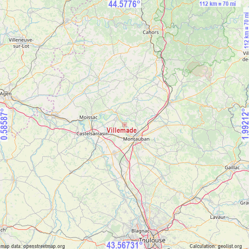
Villemade GPS coordinates[2]
44° 4' 28.596" North, 1° 17' 20.4" East
| Map corner | latitude | longitude |
|---|---|---|
| Upper-left | 44.5776°, | 0.58587° |
| Center: | 44.07461°, | 1.289° |
| Lower-right: | 43.56731°, | 1.99212° |
| Map W x H: | 112.3×112.3 km | = 69.8×69.8mi |
| max Lat: | 51.07786° ⇑86.5% North |
| Villemade: | 44.07461° |
| min Lat: | ⇓13.5% South 41.3874° |
| min Long | Villemade | max Long |
| -5.08615° | 1.289° | 9.52242° |
| W 34.3%⇐ | ⇒65.7% E |
Elevation
Elevation of Villemade is 86 m = 282 ft, and this is 107.7 m = 353 ft below average elevation for this country.
| Max E: |
2333 m = 7654 ft | 66.6% |
| Avg. | 193.7 m = 635 ft | |
| Villemade | 86 m = 282 ft | |
Min E: |
-1 m = -3 ft | 33.4% |
See also: France elevation on elevation.city.
Geographical zone
Villemade is located in North temperate zone (between Tropic of Cancer and the Arctic Circle). Distance of this Northern Tropic circle is 2294.7 km =1425.9 mi to South.| Distance of | km | miles | from Villemade |
|---|---|---|---|
| North Pole | 5106.4 | 3173 | to North |
| Arctic Circle | 2500.5 | 1553.7 | to North |
| Tropic Cancer | 2294.7 | 1425.9 | to South |
| Equator | 4900.6 | 3045.1 | to South |


Nearby cities:
15 places around Villemade: (largest is in red/bold)
• Albefeuille-Lagarde
3.7 km =2.3 mi,  216°
216°
• Albias
12.8 km =8 mi,  82°
82°
• Bressols
12.5 km =7.8 mi,  161°
161°
• Escatalens
12.8 km =8 mi, 218°
• Labastide-du-Temple
7.5 km =4.7 mi,  278°
278°
• Lacourt-Saint-Pierre
10.1 km =6.3 mi,  191°
191°
• Lafrançaise
7 km =4.3 mi,  327°
327°
• Lamothe-Capdeville
6.8 km =4.2 mi,  86°
86°
• Meauzac
4.2 km =2.6 mi,  291°
291°
• Mirabel
13 km =8.1 mi,  54°
54°
• Montauban
8.7 km =5.4 mi,  136°
136°
• Montbeton
6.5 km =4 mi,  172°
172°
• Puycornet
10.7 km =6.6 mi,  26°
26°
• Saint-Porquier
11.8 km =7.3 mi,  227°
227°
• Vazerac
12.9 km =8 mi,  358°
358°
Sources, notices
• [Note1] Compared only with cities in France existing in our database
• [Src1] Map data: © OpenStreetMap contributors (CC-BY-SA)
• [Src2] Other city data from geonames.org with taken over terms of usage.
• [Src3] Geographical zone / Annual Mean Temperature by Robert A. Rohde @ Wikipedia
