Aïcirits-Camou-Suhast geodata
Aïcirits-Camou-Suhast (Nouvelle-Aquitaine) is a populated place; located in France in Europe/Paris (GMT+2) time zone. With population of 605 people, there are 13241 cities with bigger population in this country. Compared to other cities in France, 95% of cities are located further ↑North; 88.3% of cities are located further →East and 77% of cities have higher elevation than Aïcirits-Camou-Suhast. Note1
Administrative division(s):
- Level 1: Nouvelle-Aquitaine
- Level 2: Département des Pyrénées-Atlantiques
- Level 3: Arrondissement de Bayonne
- Level 4: Aïcirits-Camou-Suhast
Current local time in Aïcirits-Camou-Suhast:
03:45 PM, SaturdayDifference from your time zone: hours


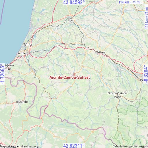
Aïcirits-Camou-Suhast GPS coordinates[2]
43° 20' 12.012" North, 1° 1' 24.708" West
| Map corner | latitude | longitude |
|---|---|---|
| Upper-left | 43.84592°, | -1.72665° |
| Center: | 43.33667°, | -1.02353° |
| Lower-right: | 42.82311°, | -0.3204° |
| Map W x H: | 113.7×113.7 km | = 70.6×70.6mi |
| max Lat: | 51.07786° ⇑95% North |
| Aïcirits-Camou-Suhast: | 43.33667° |
| min Lat: | ⇓5% South 41.3874° |
| min Long | Aïcirits-Camou | max Long |
| -5.08615° | -1.02353° | 9.52242° |
| W 11.7%⇐ | ⇒88.3% E |
Elevation
Elevation of Aïcirits-Camou-Suhast is 62 m = 203 ft, and this is 131.7 m = 432 ft below average elevation for this country.
| Max E: |
2333 m = 7654 ft | 77% |
| Avg. | 193.7 m = 635 ft | |
| Aïcirits-Camou-Suhast | 62 m = 203 ft | |
Min E: |
-1 m = -3 ft | 23% |
See also: France elevation on elevation.city.
Geographical zone
Aïcirits-Camou-Suhast is located in North temperate zone (between Tropic of Cancer and the Arctic Circle). Distance of this Northern Tropic circle is 2212.7 km =1374.9 mi to South.| Distance of | km | miles | from Aïcirits-Camou-Suhast |
|---|---|---|---|
| North Pole | 5188.5 | 3224 | to North |
| Arctic Circle | 2582.6 | 1604.8 | to North |
| Tropic Cancer | 2212.7 | 1374.9 | to South |
| Equator | 4818.6 | 2994.1 | to South |


Nearby cities:
15 places around Aïcirits-Camou-Suhast: (largest is in red/bold)
• Beyrie-sur-Joyeuse
4.1 km =2.5 mi,  237°
237°
• Bidache
18.8 km =11.7 mi,  329°
329°
• Came
16.9 km =10.5 mi, 332°
• Carresse-Cassaber
16.4 km =10.2 mi,  6°
6°
• Chéraute
17.2 km =10.7 mi,  133°
133°
• Espès-Undurein
13.8 km =8.6 mi,  124°
124°
• Garindein
17.1 km =10.6 mi,  146°
146°
• Hélette
18.1 km =11.2 mi,  259°
259°
• Mauléon-Licharre
16.8 km =10.4 mi,  136°
136°
• Ordiarp
17.9 km =11.1 mi,  158°
158°
• Orègue
11 km =6.8 mi,  305°
305°
• Saint-Palais
1.2 km =0.7 mi,  221°
221°
• Salies-de-Béarn
17.3 km =10.7 mi,  27°
27°
• Sauveterre-de-Béarn
10.1 km =6.3 mi,  45°
45°
• Viodos-Abense-de-Bas
15.7 km =9.8 mi, 132°
In other languages:
- In Spanish: Aiziritze
- In France: Aicirits
- In Russian: Аисиритс-Каму-Сюаст
- In Chinese: 艾西里特康乌叙阿斯
Sources, notices
• [Note1] Compared only with cities in France existing in our database
• [Src1] Map data: © OpenStreetMap contributors (CC-BY-SA)
• [Src2] Other city data from geonames.org with taken over terms of usage.
• [Src3] Geographical zone / Annual Mean Temperature by Robert A. Rohde @ Wikipedia
