Saint-Palais geodata
Saint-Palais (Nouvelle-Aquitaine) is a populated place; located in France in Europe/Paris (GMT+2) time zone. With population of 2,038 people, there are 4711 cities with bigger population in this country. Compared to other cities in France, 95.2% of cities are located further ↑North; 88.5% of cities are located further →East and 81.5% of cities have higher elevation than Saint-Palais. Note1
Administrative division(s):
- Level 1: Nouvelle-Aquitaine
- Level 2: Département des Pyrénées-Atlantiques
- Level 3: Arrondissement de Bayonne
- Level 4: Saint-Palais


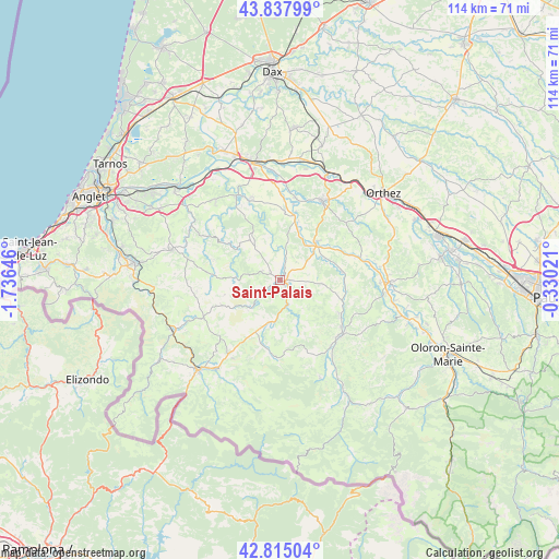
Saint-Palais GPS coordinates[2]
43° 19' 43.212" North, 1° 1' 59.988" West
| Map corner | latitude | longitude |
|---|---|---|
| Upper-left | 43.83799°, | -1.73646° |
| Center: | 43.32867°, | -1.03333° |
| Lower-right: | 42.81504°, | -0.33021° |
| Map W x H: | 113.7×113.7 km | = 70.6×70.6mi |
| max Lat: | 51.07786° ⇑95.2% North |
| Saint-Palais: | 43.32867° |
| min Lat: | ⇓4.8% South 41.3874° |
| min Long | Saint-Palais | max Long |
| -5.08615° | -1.03333° | 9.52242° |
| W 11.5%⇐ | ⇒88.5% E |
Elevation
Elevation of Saint-Palais is 51 m = 167 ft, and this is 142.7 m = 468 ft below average elevation for this country.
| Max E: |
2333 m = 7654 ft | 81.5% |
| Avg. | 193.7 m = 635 ft | |
| Saint-Palais | 51 m = 167 ft | |
Min E: |
-1 m = -3 ft | 18.5% |
See also: France elevation on elevation.city.
Geographical zone
Saint-Palais is located in North temperate zone (between Tropic of Cancer and the Arctic Circle). Distance of this Northern Tropic circle is 2211.8 km =1374.3 mi to South.| Distance of | km | miles | from Saint-Palais |
|---|---|---|---|
| North Pole | 5189.4 | 3224.5 | to North |
| Arctic Circle | 2583.5 | 1605.3 | to North |
| Tropic Cancer | 2211.8 | 1374.3 | to South |
| Equator | 4817.7 | 2993.6 | to South |


Nearby cities:
15 places around Saint-Palais: (largest is in red/bold)
• Aïcirits-Camou-Suhast
1.2 km =0.7 mi,  41°
41°
• Beyrie-sur-Joyeuse
3 km =1.9 mi,  243°
243°
• Came
17.4 km =10.8 mi,  336°
336°
• Carresse-Cassaber
17.4 km =10.8 mi,  8°
8°
• Chéraute
17.2 km =10.7 mi,  129°
129°
• Espès-Undurein
14 km =8.7 mi,  119°
119°
• Garindein
16.8 km =10.4 mi,  142°
142°
• Hélette
17.2 km =10.7 mi,  262°
262°
• Irissarry
17.9 km =11.1 mi, 243°
• Mauléon-Licharre
16.8 km =10.4 mi, 132°
• Ordiarp
17.4 km =10.8 mi,  155°
155°
• Orègue
11 km =6.8 mi,  311°
311°
• Salies-de-Béarn
18.4 km =11.4 mi,  28°
28°
• Sauveterre-de-Béarn
11.3 km =7 mi,  45°
45°
• Viodos-Abense-de-Bas
15.7 km =9.8 mi, 127°
Sources, notices
• [Note1] Compared only with cities in France existing in our database
• [Src1] Map data: © OpenStreetMap contributors (CC-BY-SA)
• [Src2] Other city data from geonames.org with taken over terms of usage.
• [Src3] Geographical zone / Annual Mean Temperature by Robert A. Rohde @ Wikipedia
