Agde geodata
Agde (Occitanie) is a populated place; located in France in Europe/Paris (GMT+2) time zone. With population of 23,001 people, there are 389 cities with bigger population in this country. Compared to other cities in France, 95.5% of cities are located further ↑North; 64% of cities are located further ←West and 95.4% of cities have higher elevation than Agde. Note1
Administrative division(s):
- Level 1: Occitanie
- Level 2: Département de l'Hérault
- Level 3: Arrondissement de Béziers
- Level 4: Agde


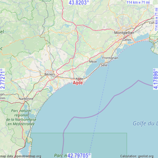
Agde GPS coordinates[2]
43° 18' 38.988" North, 3° 28' 32.988" East
| Map corner | latitude | longitude |
|---|---|---|
| Upper-left | 43.8203°, | 2.77271° |
| Center: | 43.31083°, | 3.47583° |
| Lower-right: | 42.79705°, | 4.17896° |
| Map W x H: | 113.8×113.8 km | = 70.7×70.7mi |
| max Lat: | 51.07786° ⇑95.5% North |
| Agde: | 43.31083° |
| min Lat: | ⇓4.5% South 41.3874° |
| min Long | Agde | max Long |
| -5.08615° | 3.47583° | 9.52242° |
| W 64%⇐ | ⇒36% E |
Elevation
Elevation of Agde is 16 m = 52 ft, and this is 177.7 m = 583 ft below average elevation for this country.
| Max E: |
2333 m = 7654 ft | 95.4% |
| Avg. | 193.7 m = 635 ft | |
| Agde | 16 m = 52 ft | |
Min E: |
-1 m = -3 ft | 4.6% |
See also: France elevation on elevation.city.
Geographical zone
Agde is located in North temperate zone (between Tropic of Cancer and the Arctic Circle). Distance of this Northern Tropic circle is 2209.8 km =1373.1 mi to South.| Distance of | km | miles | from Agde |
|---|---|---|---|
| North Pole | 5191.3 | 3225.7 | to North |
| Arctic Circle | 2585.5 | 1606.6 | to North |
| Tropic Cancer | 2209.8 | 1373.1 | to South |
| Equator | 4815.7 | 2992.3 | to South |


Nearby cities:
15 places around Agde: (largest is in red/bold)
• Bessan
7.1 km =4.4 mi,  323°
323°
• Castelnau-de-Guers
14 km =8.7 mi,  347°
347°
• Cers
13.9 km =8.6 mi,  275°
275°
• Florensac
8.1 km =5 mi, 354°
• Le Cap d'Agde
4.8 km =3 mi,  140°
140°
• Marseillan
6.6 km =4.1 mi,  39°
39°
• Montblanc
12.8 km =8 mi, 316°
• Mèze
16.5 km =10.3 mi, 39°
• Pinet
10.9 km =6.8 mi,  14°
14°
• Pomérols
9.2 km =5.7 mi, 12°
• Portiragnes
11.5 km =7.1 mi,  266°
266°
• Saint-Thibéry
10.6 km =6.6 mi,  333°
333°
• Valros
15 km =9.3 mi, 323°
• Vias
4.7 km =2.9 mi, 270°
• Villeneuve-lès-Béziers
15.8 km =9.8 mi, 271°
Sources, notices
• [Note1] Compared only with cities in France existing in our database
• [Src1] Map data: © OpenStreetMap contributors (CC-BY-SA)
• [Src2] Other city data from geonames.org with taken over terms of usage.
• [Src3] Geographical zone / Annual Mean Temperature by Robert A. Rohde @ Wikipedia
