Vimy geodata
Vimy (Hauts-de-France) is a populated place; located in France in Europe/Paris (GMT+2) time zone. With population of 4,797 people, there are 2071 cities with bigger population in this country. Compared to other cities in France, 96.2% of cities are located further ↓South; 55.1% of cities are located further ←West and 70.5% of cities have higher elevation than Vimy. Note1
Administrative division(s):
- Level 1: Hauts-de-France
- Level 2: Pas-de-Calais
- Level 3: Arrondissement de Lens
- Level 4: Vimy


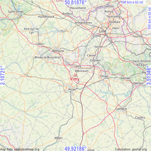
Vimy GPS coordinates[2]
50° 22' 20.748" North, 2° 48' 37.224" East
| Map corner | latitude | longitude |
|---|---|---|
| Upper-left | 50.81876°, | 2.10721° |
| Center: | 50.37243°, | 2.81034° |
| Lower-right: | 49.92186°, | 3.51346° |
| Map W x H: | 99.7×99.7 km | = 62×62mi |
| max Lat: | 51.07786° ⇑3.8% North |
| Vimy: | 50.37243° |
| min Lat: | ⇓96.2% South 41.3874° |
| min Long | Vimy | max Long |
| -5.08615° | 2.81034° | 9.52242° |
| W 55.1%⇐ | ⇒44.9% E |
Elevation
Elevation of Vimy is 77 m = 253 ft, and this is 116.7 m = 383 ft below average elevation for this country.
| Max E: |
2333 m = 7654 ft | 70.5% |
| Avg. | 193.7 m = 635 ft | |
| Vimy | 77 m = 253 ft | |
Min E: |
-1 m = -3 ft | 29.5% |
See also: France elevation on elevation.city.
Geographical zone
Vimy is located in North temperate zone (between Tropic of Cancer and the Arctic Circle). Distance of this North polar circle is 1800.3 km =1118.7 mi to North.| Distance of | km | miles | from Vimy |
|---|---|---|---|
| North Pole | 4406.2 | 2737.9 | to North |
| Arctic Circle | 1800.3 | 1118.7 | to North |
| Tropic Cancer | 2995 | 1861 | to South |
| Equator | 5600.9 | 3480.2 | to South |


Nearby cities:
15 places around Vimy: (largest is in red/bold)
• Acheville
5.3 km =3.3 mi,  75°
75°
• Angres
5.1 km =3.2 mi,  316°
316°
• Arleux-en-Gohelle
4.5 km =2.8 mi,  103°
103°
• Avion
4.5 km =2.8 mi,  18°
18°
• Bailleul-Sir-Berthoult
4.8 km =3 mi,  143°
143°
• Farbus
2.1 km =1.3 mi,  150°
150°
• Givenchy-en-Gohelle
3.3 km =2.1 mi,  307°
307°
• Liévin
5.7 km =3.5 mi,  338°
338°
• Méricourt
4.9 km =3 mi,  49°
49°
• Neuville-Saint-Vaast
3.8 km =2.4 mi,  243°
243°
• Roclincourt
5.4 km =3.4 mi,  197°
197°
• Souchez
5.5 km =3.4 mi,  294°
294°
• Thélus
2.1 km =1.3 mi, 197°
• Willerval
3 km =1.9 mi,  125°
125°
• Éleu-dit-Leauwette
5.5 km =3.4 mi,  0°
0°
Sources, notices
• [Note1] Compared only with cities in France existing in our database
• [Src1] Map data: © OpenStreetMap contributors (CC-BY-SA)
• [Src2] Other city data from geonames.org with taken over terms of usage.
• [Src3] Geographical zone / Annual Mean Temperature by Robert A. Rohde @ Wikipedia
