Escaudain geodata
Escaudain (Hauts-de-France) is a populated place; located in France in Europe/Paris (GMT+2) time zone. With population of 9,479 people, there are 1008 cities with bigger population in this country. Compared to other cities in France, 95.9% of cities are located further ↓South; 62.6% of cities are located further ←West and 86.2% of cities have higher elevation than Escaudain. Note1
Administrative division(s):
- Level 1: Hauts-de-France
- Level 2: Nord
- Level 3: Arrondissement de Valenciennes
- Level 4: Escaudain


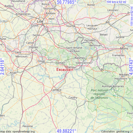
Escaudain GPS coordinates[2]
50° 19' 59.34" North, 3° 20' 39.48" East
| Map corner | latitude | longitude |
|---|---|---|
| Upper-left | 50.77985°, | 2.64118° |
| Center: | 50.33315°, | 3.3443° |
| Lower-right: | 49.88221°, | 4.04743° |
| Map W x H: | 99.8×99.8 km | = 62×62mi |
| max Lat: | 51.07786° ⇑4.1% North |
| Escaudain: | 50.33315° |
| min Lat: | ⇓95.9% South 41.3874° |
| min Long | Escaudain | max Long |
| -5.08615° | 3.3443° | 9.52242° |
| W 62.6%⇐ | ⇒37.4% E |
Elevation
Elevation of Escaudain is 39 m = 128 ft, and this is 154.7 m = 508 ft below average elevation for this country.
| Max E: |
2333 m = 7654 ft | 86.2% |
| Avg. | 193.7 m = 635 ft | |
| Escaudain | 39 m = 128 ft | |
Min E: |
-1 m = -3 ft | 13.8% |
See also: France elevation on elevation.city.
Geographical zone
Escaudain is located in North temperate zone (between Tropic of Cancer and the Arctic Circle). Distance of this North polar circle is 1804.7 km =1121.4 mi to North.| Distance of | km | miles | from Escaudain |
|---|---|---|---|
| North Pole | 4410.5 | 2740.6 | to North |
| Arctic Circle | 1804.7 | 1121.4 | to North |
| Tropic Cancer | 2990.6 | 1858.3 | to South |
| Equator | 5596.5 | 3477.5 | to South |


Nearby cities:
15 places around Escaudain: (largest is in red/bold)
• Abscon
3.1 km =1.9 mi,  270°
270°
• Denain
3.6 km =2.2 mi,  96°
96°
• Douchy-les-Mines
5 km =3.1 mi,  136°
136°
• Erre
3.8 km =2.4 mi,  328°
328°
• Fenain
4.9 km =3 mi,  319°
319°
• Haveluy
4.8 km =3 mi,  62°
62°
• Hornaing
3.9 km =2.4 mi,  352°
352°
• Hélesmes
4.3 km =2.7 mi,  14°
14°
• Lourches
2.3 km =1.4 mi,  164°
164°
• Mastaing
4.1 km =2.5 mi,  223°
223°
• Neuville-sur-Escaut
3.7 km =2.3 mi,  173°
173°
• Rœulx
3.8 km =2.4 mi,  191°
191°
• Somain
5.4 km =3.4 mi,  303°
303°
• Wallers
5.7 km =3.5 mi,  36°
36°
• Wavrechain-sous-Denain
4.8 km =3 mi,  91°
91°
Sources, notices
• [Note1] Compared only with cities in France existing in our database
• [Src1] Map data: © OpenStreetMap contributors (CC-BY-SA)
• [Src2] Other city data from geonames.org with taken over terms of usage.
• [Src3] Geographical zone / Annual Mean Temperature by Robert A. Rohde @ Wikipedia
