Mastaing geodata
Mastaing (Hauts-de-France) is a populated place; located in France in Europe/Paris (GMT+2) time zone. With population of 894 people, there are 9709 cities with bigger population in this country. Compared to other cities in France, 95.6% of cities are located further ↓South; 62.1% of cities are located further ←West and 87.4% of cities have higher elevation than Mastaing. Note1
Administrative division(s):
- Level 1: Hauts-de-France
- Level 2: Nord
- Level 3: Arrondissement de Valenciennes
- Level 4: Mastaing


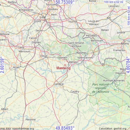
Mastaing GPS coordinates[2]
50° 18' 22.068" North, 3° 18' 16.956" East
| Map corner | latitude | longitude |
|---|---|---|
| Upper-left | 50.75309°, | 2.60159° |
| Center: | 50.30613°, | 3.30471° |
| Lower-right: | 49.85493°, | 4.00784° |
| Map W x H: | 99.9×99.9 km | = 62.1×62.1mi |
| max Lat: | 51.07786° ⇑4.4% North |
| Mastaing: | 50.30613° |
| min Lat: | ⇓95.6% South 41.3874° |
| min Long | Mastaing | max Long |
| -5.08615° | 3.30471° | 9.52242° |
| W 62.1%⇐ | ⇒37.9% E |
Elevation
Elevation of Mastaing is 36 m = 118 ft, and this is 157.7 m = 517 ft below average elevation for this country.
| Max E: |
2333 m = 7654 ft | 87.4% |
| Avg. | 193.7 m = 635 ft | |
| Mastaing | 36 m = 118 ft | |
Min E: |
-1 m = -3 ft | 12.6% |
See also: France elevation on elevation.city.
Geographical zone
Mastaing is located in North temperate zone (between Tropic of Cancer and the Arctic Circle). Distance of this North polar circle is 1807.7 km =1123.3 mi to North.| Distance of | km | miles | from Mastaing |
|---|---|---|---|
| North Pole | 4413.5 | 2742.4 | to North |
| Arctic Circle | 1807.7 | 1123.3 | to North |
| Tropic Cancer | 2987.6 | 1856.4 | to South |
| Equator | 5593.5 | 3475.6 | to South |


Nearby cities:
15 places around Mastaing: (largest is in red/bold)
• Abscon
3 km =1.9 mi,  353°
353°
• Aniche
4.5 km =2.8 mi,  306°
306°
• Auberchicourt
5.9 km =3.7 mi,  300°
300°
• Bouchain
2.4 km =1.5 mi,  162°
162°
• Escaudain
4.1 km =2.5 mi,  43°
43°
• Hordain
4.8 km =3 mi,  172°
172°
• Lieu-Saint-Amand
4.7 km =2.9 mi,  141°
141°
• Lourches
3.5 km =2.2 mi,  76°
76°
• Marcq-en-Ostrevent
5.3 km =3.3 mi,  244°
244°
• Marquette-en-Ostrevant
3.7 km =2.3 mi,  226°
226°
• Neuville-sur-Escaut
3.3 km =2.1 mi,  101°
101°
• Rœulx
2.1 km =1.3 mi,  108°
108°
• Somain
6.2 km =3.9 mi,  344°
344°
• Wasnes-au-Bac
5 km =3.1 mi,  219°
219°
• Émerchicourt
4.2 km =2.6 mi,  272°
272°
Sources, notices
• [Note1] Compared only with cities in France existing in our database
• [Src1] Map data: © OpenStreetMap contributors (CC-BY-SA)
• [Src2] Other city data from geonames.org with taken over terms of usage.
• [Src3] Geographical zone / Annual Mean Temperature by Robert A. Rohde @ Wikipedia
