Wembury geodata
Wembury (England) is a populated place; located in United Kingdom in Europe/London (GMT+1) time zone. With population of 1,819 people, there are 2767 cities with bigger population in this country. Compared to other cities in United Kingdom, 99% of cities are located further ↑North; 89% of cities are located further →East and 56.6% of cities have lower elevation than Wembury. Note1
Administrative division(s):
- Level 1: England
- Level 2: Devon
- Level 3: South Hams District
- Level 4: Wembury


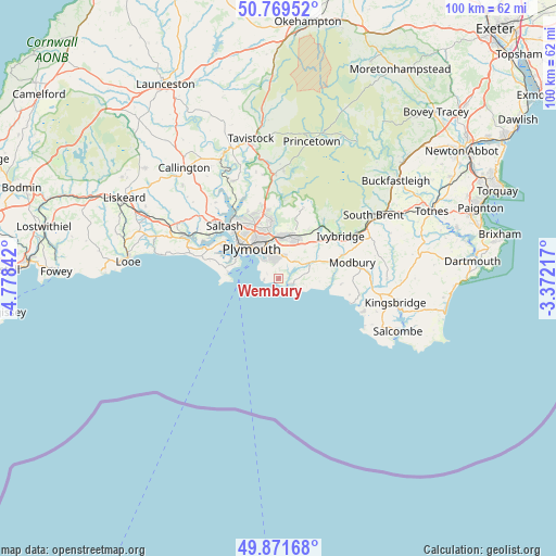
Wembury GPS coordinates[2]
50° 19' 21.792" North, 4° 4' 31.044" West
| Map corner | latitude | longitude |
|---|---|---|
| Upper-left | 50.76952°, | -4.77842° |
| Center: | 50.32272°, | -4.07529° |
| Lower-right: | 49.87168°, | -3.37217° |
| Map W x H: | 99.8×99.8 km | = 62×62mi |
| max Lat: | 60.39635° ⇑99% North |
| Wembury: | 50.32272° |
| min Lat: | ⇓1% South 34.60088° |
| min Long | Wembury | max Long |
| -7.64133° | -4.07529° | 32.95536° |
| W 11%⇐ | ⇒89% E |
Elevation
Elevation of Wembury is 71 m = 233 ft, and this is 1.9 m = 6 ft below average elevation for this country.
| Max E: |
515 m = 1690 ft | 43.4% |
| Avg. | 72.9 m = 239 ft | |
| Wembury | 71 m = 233 ft | |
Min E: |
-30 m = -98 ft | 56.6% |
See also: United Kingdom elevation on elevation.city.
Geographical zone
Wembury is located in North temperate zone (between Tropic of Cancer and the Arctic Circle). Distance of this North polar circle is 1805.8 km =1122.1 mi to North.| Distance of | km | miles | from Wembury |
|---|---|---|---|
| North Pole | 4411.7 | 2741.3 | to North |
| Arctic Circle | 1805.8 | 1122.1 | to North |
| Tropic Cancer | 2989.4 | 1857.5 | to South |
| Equator | 5595.4 | 3476.8 | to South |


Nearby cities:
15 places around Wembury: (largest is in red/bold)
• Brixton
4.3 km =2.7 mi,  44°
44°
• Ivybridge
13.4 km =8.3 mi,  55°
55°
• Landrake
18.9 km =11.7 mi,  306°
306°
• Loddiswell
19.5 km =12.1 mi,  90°
90°
• Millbrook
10.3 km =6.4 mi,  286°
286°
• Modbury
13.7 km =8.5 mi,  77°
77°
• Newton Ferrers
2.7 km =1.7 mi,  109°
109°
• Plymouth
7.3 km =4.5 mi,  318°
318°
• Plympton
7.6 km =4.7 mi,  8°
8°
• Plymstock
4.3 km =2.7 mi,  345°
345°
• Saltash
14.4 km =8.9 mi, 312°
• Thurlestone
16.2 km =10.1 mi, 111°
• Torpoint
10.3 km =6.4 mi,  304°
304°
• Yealmpton
6.1 km =3.8 mi, 62°
• Yelverton
18.9 km =11.7 mi,  358°
358°
Sources, notices
• [Note1] Compared only with cities in United Kingdom existing in our database
• [Src1] Map data: © OpenStreetMap contributors (CC-BY-SA)
• [Src2] Other city data from geonames.org with taken over terms of usage.
• [Src3] Geographical zone / Annual Mean Temperature by Robert A. Rohde @ Wikipedia
