Plymstock geodata
Plymstock (England) is a populated place; located in United Kingdom in Europe/London (GMT+1) time zone. With population of 24,103 people, there are 490 cities with bigger population in this country. Compared to other cities in United Kingdom, 98.7% of cities are located further ↑North; 89.3% of cities are located further →East and 74.7% of cities have higher elevation than Plymstock. Note1


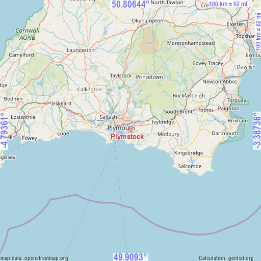
Plymstock GPS coordinates[2]
50° 21' 35.964" North, 4° 5' 25.764" West
| Map corner | latitude | longitude |
|---|---|---|
| Upper-left | 50.80644°, | -4.79361° |
| Center: | 50.35999°, | -4.09049° |
| Lower-right: | 49.9093°, | -3.38736° |
| Map W x H: | 99.8×99.8 km | = 62×62mi |
| max Lat: | 60.39635° ⇑98.7% North |
| Plymstock: | 50.35999° |
| min Lat: | ⇓1.3% South 34.60088° |
| min Long | Plymstock | max Long |
| -7.64133° | -4.09049° | 32.95536° |
| W 10.7%⇐ | ⇒89.3% E |
Elevation
Elevation of Plymstock is 27 m = 89 ft, and this is 45.9 m = 151 ft below average elevation for this country.
| Max E: |
515 m = 1690 ft | 74.7% |
| Avg. | 72.9 m = 239 ft | |
| Plymstock | 27 m = 89 ft | |
Min E: |
-30 m = -98 ft | 25.3% |
See also: United Kingdom elevation on elevation.city.
Geographical zone
Plymstock is located in North temperate zone (between Tropic of Cancer and the Arctic Circle). Distance of this North polar circle is 1801.7 km =1119.5 mi to North.| Distance of | km | miles | from Plymstock |
|---|---|---|---|
| North Pole | 4407.6 | 2738.8 | to North |
| Arctic Circle | 1801.7 | 1119.5 | to North |
| Tropic Cancer | 2993.6 | 1860.1 | to South |
| Equator | 5599.5 | 3479.4 | to South |


Nearby cities:
15 places around Plymstock: (largest is in red/bold)
• Bere Alston
15.3 km =9.5 mi,  332°
332°
• Brixton
4.2 km =2.6 mi,  105°
105°
• Buckland Monachorum
15.3 km =9.5 mi,  349°
349°
• Dousland
15.7 km =9.8 mi,  7°
7°
• Ivybridge
12.6 km =7.8 mi,  74°
74°
• Millbrook
8.9 km =5.5 mi,  262°
262°
• Modbury
14.5 km =9 mi,  94°
94°
• Newton Ferrers
6.2 km =3.9 mi,  144°
144°
• Plymouth
3.9 km =2.4 mi,  288°
288°
• Plympton
4 km =2.5 mi,  32°
32°
• Saltash
11 km =6.8 mi,  300°
300°
• Torpoint
7.6 km =4.7 mi,  282°
282°
• Wembury
4.3 km =2.7 mi,  165°
165°
• Yealmpton
6.6 km =4.1 mi,  101°
101°
• Yelverton
14.8 km =9.2 mi,  1°
1°
Sources, notices
• [Note1] Compared only with cities in United Kingdom existing in our database
• [Src1] Map data: © OpenStreetMap contributors (CC-BY-SA)
• [Src2] Other city data from geonames.org with taken over terms of usage.
• [Src3] Geographical zone / Annual Mean Temperature by Robert A. Rohde @ Wikipedia
