Hawes geodata
Hawes (England) is a populated place; located in United Kingdom in Europe/London (GMT+1) time zone. With population of 887 people, there are 3835 cities with bigger population in this country. Compared to other cities in United Kingdom, 80.8% of cities are located further ↓South; 59% of cities are located further →East and 98.6% of cities have lower elevation than Hawes. Note1
Administrative division(s):
- Level 1: England
- Level 2: North Yorkshire
- Level 3: Richmondshire District
- Level 4: Hawes


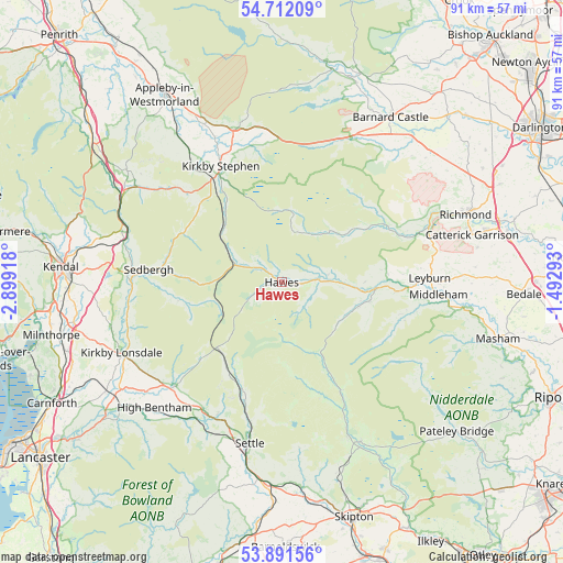
Hawes GPS coordinates[2]
54° 18' 13.932" North, 2° 11' 45.78" West
| Map corner | latitude | longitude |
|---|---|---|
| Upper-left | 54.71209°, | -2.89918° |
| Center: | 54.30387°, | -2.19605° |
| Lower-right: | 53.89156°, | -1.49293° |
| Map W x H: | 91.2×91.2 km | = 56.7×56.7mi |
| max Lat: | 60.39635° ⇑19.2% North |
| Hawes: | 54.30387° |
| min Lat: | ⇓80.8% South 34.60088° |
| min Long | Hawes | max Long |
| -7.64133° | -2.19605° | 32.95536° |
| W 41%⇐ | ⇒59% E |
Elevation
Elevation of Hawes is 236 m = 774 ft, and this is 163.1 m = 535 ft above average elevation for this country.
| Max E: |
515 m = 1690 ft | 1.4% |
| Hawes | 236 m 774 ft | |
| Avg. | 72.9 m = 239 ft | |
Min E: |
-30 m = -98 ft | 98.6% |
See also: United Kingdom elevation on elevation.city.
Geographical zone
Hawes is located in North temperate zone (between Tropic of Cancer and the Arctic Circle). Distance of this North polar circle is 1363.1 km =847 mi to North.| Distance of | km | miles | from Hawes |
|---|---|---|---|
| North Pole | 3969 | 2466.2 | to North |
| Arctic Circle | 1363.1 | 847 | to North |
| Tropic Cancer | 3432.1 | 2132.6 | to South |
| Equator | 6038 | 3751.8 | to South |


Nearby cities:
15 places around Hawes: (largest is in red/bold)
• Barningham
29.4 km =18.3 mi,  45°
45°
• Bowes
26.3 km =16.3 mi,  26°
26°
• Brignall
29.9 km =18.6 mi,  41°
41°
• Burton in Lonsdale
28.2 km =17.5 mi,  231°
231°
• Grassington
28.9 km =18 mi,  153°
153°
• High Bentham
29.1 km =18.1 mi,  224°
224°
• Ingleton
24.3 km =15.1 mi, 226°
• Kirkby Lonsdale
28.5 km =17.7 mi,  246°
246°
• Kirkby Stephen
21.2 km =13.2 mi,  332°
332°
• Leyburn
23.7 km =14.7 mi,  88°
88°
• Middleham
25.2 km =15.7 mi, 94°
• Reeth
18.8 km =11.7 mi,  60°
60°
• Sedbergh
21.4 km =13.3 mi,  275°
275°
• Settle
26.7 km =16.6 mi,  191°
191°
• Startforth
31.2 km =19.4 mi, 33°
Sources, notices
• [Note1] Compared only with cities in United Kingdom existing in our database
• [Src1] Map data: © OpenStreetMap contributors (CC-BY-SA)
• [Src2] Other city data from geonames.org with taken over terms of usage.
• [Src3] Geographical zone / Annual Mean Temperature by Robert A. Rohde @ Wikipedia
