Portpatrick geodata
Portpatrick (Scotland) is a populated place; located in United Kingdom in Europe/London (GMT+1) time zone. With population of 620 people, there are 4515 cities with bigger population in this country. Compared to other cities in United Kingdom, 85.3% of cities are located further ↓South; 96.7% of cities are located further →East and 97.5% of cities have higher elevation than Portpatrick. Note1


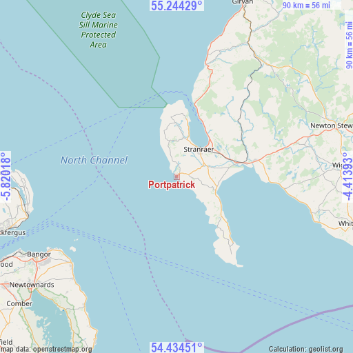
Portpatrick GPS coordinates[2]
54° 50' 29.148" North, 5° 7' 1.38" West
| Map corner | latitude | longitude |
|---|---|---|
| Upper-left | 55.24429°, | -5.82018° |
| Center: | 54.84143°, | -5.11705° |
| Lower-right: | 54.43451°, | -4.41393° |
| Map W x H: | 90×90 km | = 55.9×55.9mi |
| max Lat: | 60.39635° ⇑14.7% North |
| Portpatrick: | 54.84143° |
| min Lat: | ⇓85.3% South 34.60088° |
| min Long | Portpatrick | max Long |
| -7.64133° | -5.11705° | 32.95536° |
| W 3.3%⇐ | ⇒96.7% E |
Elevation
Elevation of Portpatrick is 6 m = 20 ft, and this is 66.9 m = 219 ft below average elevation for this country.
| Max E: |
515 m = 1690 ft | 97.5% |
| Avg. | 72.9 m = 239 ft | |
| Portpatrick | 6 m = 20 ft | |
Min E: |
-30 m = -98 ft | 2.5% |
See also: United Kingdom elevation on elevation.city.
Geographical zone
Portpatrick is located in North temperate zone (between Tropic of Cancer and the Arctic Circle). Distance of this North polar circle is 1303.4 km =809.9 mi to North.| Distance of | km | miles | from Portpatrick |
|---|---|---|---|
| North Pole | 3909.3 | 2429.1 | to North |
| Arctic Circle | 1303.4 | 809.9 | to North |
| Tropic Cancer | 3491.9 | 2169.8 | to South |
| Equator | 6097.8 | 3789 | to South |


Nearby cities:
15 places around Portpatrick: (largest is in red/bold)
• Ballywalter
40.7 km =25.3 mi,  215°
215°
• Bangor
41.1 km =25.5 mi,  239°
239°
• Cairnryan
15.7 km =9.8 mi,  23°
23°
• Carrickfergus
46.3 km =28.8 mi,  252°
252°
• Donaghadee
34.9 km =21.7 mi,  230°
230°
• Glenluce
20.1 km =12.5 mi,  78°
78°
• Greyabbey
44.4 km =27.6 mi, 219°
• Larne
44.8 km =27.8 mi,  271°
271°
• Millisle
37.2 km =23.1 mi, 225°
• Newton Stewart
42.5 km =26.4 mi,  72°
72°
• Newtownards
46.1 km =28.6 mi, 233°
• Stranraer
8.9 km =5.5 mi,  40°
40°
• Whitehead
39.2 km =24.4 mi,  255°
255°
• Whithorn
46.6 km =29 mi,  105°
105°
• Wigtown
43.1 km =26.8 mi,  86°
86°
Sources, notices
• [Note1] Compared only with cities in United Kingdom existing in our database
• [Src1] Map data: © OpenStreetMap contributors (CC-BY-SA)
• [Src2] Other city data from geonames.org with taken over terms of usage.
• [Src3] Geographical zone / Annual Mean Temperature by Robert A. Rohde @ Wikipedia
